You are here: Home > Network List > XW97 - Tien Shan Continental Dynamics Stations List
> Station POGR XW.POGR > Earthquake Result Viewer
POGR XW.POGR - Earthquake Result Viewer
| Earthquake location: |
Mariana Islands Region |
| Earthquake latitude/longitude: |
17.4/147.5 |
| Earthquake time(UTC): |
2000/05/02 (123) 15:03:36 GMT |
| Earthquake Depth: |
55 km |
| Earthquake Magnitude: |
5.8 MB, 5.9 MW, 5.9 MW |
| Earthquake Catalog/Contributor: |
WHDF/NEIC |
|
| Network: |
XW Tien Shan Continental Dynamics |
| Station: |
POGR XW.POGR |
| Lat/Lon: |
41.02 N/75.55 E |
| Elevation: |
2357 m |
|
| Distance: |
65.3 deg |
| Az: |
307.612 deg |
| Baz: |
87.97 deg |
| Ray Param: |
0.05826142 |
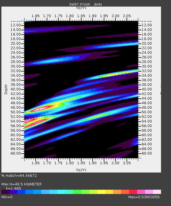
| Estimated Moho Depth: |
48.5 km |
| Estimated Crust Vp/Vs: |
1.66 |
| Assumed Crust Vp: |
6.491 km/s |
| Estimated Crust Vs: |
3.898 km/s |
| Estimated Crust Poisson's Ratio: |
0.22 |
|
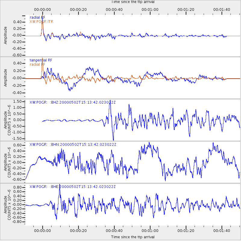
| Radial Match: |
94.44672 % |
| Radial Bump: |
380 |
| Transverse Match: |
42.512714 % |
| Transverse Bump: |
400 |
| SOD ConfigId: |
20082 |
| Insert Time: |
2010-02-26 15:45:37.075 +0000 |
| GWidth: |
2.5 |
| Max Bumps: |
400 |
| Tol: |
0.001 |
|
Signal To Noise
| Channel | StoN | STA | LTA |
| XW:POGR: :BHN:20000502T15:13:42.023022Z | 0.6407589 | 1.4589057E-7 | 2.2768405E-7 |
| XW:POGR: :BHE:20000502T15:13:42.023022Z | 2.8854122 | 6.6207406E-8 | 2.2945562E-8 |
| XW:POGR: :BHZ:20000502T15:13:42.023022Z | 4.5345774 | 1.5922092E-7 | 3.5112624E-8 |
| Arrivals |
| Ps | 5.2 SECOND |
| PpPs | 19 SECOND |
| PsPs/PpSs | 24 SECOND |


