You are here: Home > Network List > G - GEOSCOPE Stations List
> Station RER Riviere de l'Est, La Reunion (Indian Ocean) > Earthquake Result Viewer
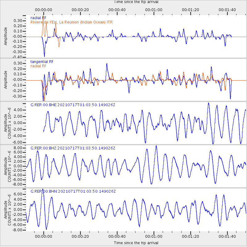
RER Riviere de l'Est, La Reunion (Indian Ocean) - Earthquake Result Viewer
*The percent match for this event was below the threshold and hence no stack was calculated.
| Earthquake location: |
South Sandwich Islands Region |
| Earthquake latitude/longitude: |
-56.1/-27.9 |
| Earthquake time(UTC): |
2021/07/17 (198) 00:53:24 GMT |
| Earthquake Depth: |
96 km |
| Earthquake Magnitude: |
5.7 Mww |
| Earthquake Catalog/Contributor: |
NEIC PDE/us |
|
| Network: |
G GEOSCOPE |
| Station: |
RER Riviere de l'Est, La Reunion (Indian Ocean) |
| Lat/Lon: |
21.16 S/55.75 E |
| Elevation: |
834 m |
|
| Distance: |
69.2 deg |
| Az: |
97.059 deg |
| Baz: |
216.562 deg |
| Ray Param: |
$rayparam |
*The percent match for this event was below the threshold and hence was not used in the summary stack. |
|
| Radial Match: |
61.84961 % |
| Radial Bump: |
400 |
| Transverse Match: |
50.27587 % |
| Transverse Bump: |
400 |
| SOD ConfigId: |
25131211 |
| Insert Time: |
2021-07-31 00:55:25.782 +0000 |
| GWidth: |
2.5 |
| Max Bumps: |
400 |
| Tol: |
0.001 |
|
Signal To Noise
| Channel | StoN | STA | LTA |
| G:RER:00:BHZ:20210717T01:03:50.149026Z | 1.1140032 | 3.6140907E-6 | 3.2442372E-6 |
| G:RER:00:BHN:20210717T01:03:50.149026Z | 2.218214 | 5.1916277E-6 | 2.3404539E-6 |
| G:RER:00:BHE:20210717T01:03:50.149026Z | 1.202219 | 2.6361886E-6 | 2.192769E-6 |
| Arrivals |
| Ps | |
| PpPs | |
| PsPs/PpSs | |


