You are here: Home > Network List > GT - Global Telemetered Seismograph Network (USAF/USGS) Stations List
> Station LPAZ La Paz , Bolivia > Earthquake Result Viewer
LPAZ La Paz , Bolivia - Earthquake Result Viewer
| Earthquake location: |
South Sandwich Islands Region |
| Earthquake latitude/longitude: |
-56.1/-27.9 |
| Earthquake time(UTC): |
2021/07/17 (198) 00:53:24 GMT |
| Earthquake Depth: |
96 km |
| Earthquake Magnitude: |
5.7 Mww |
| Earthquake Catalog/Contributor: |
NEIC PDE/us |
|
| Network: |
GT Global Telemetered Seismograph Network (USAF/USGS) |
| Station: |
LPAZ La Paz , Bolivia |
| Lat/Lon: |
16.17 S/68.08 W |
| Elevation: |
4817 m |
|
| Distance: |
50.2 deg |
| Az: |
306.107 deg |
| Baz: |
151.897 deg |
| Ray Param: |
0.067911774 |
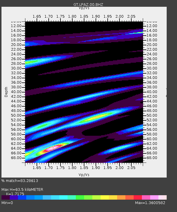
| Estimated Moho Depth: |
63.5 km |
| Estimated Crust Vp/Vs: |
1.72 |
| Assumed Crust Vp: |
6.454 km/s |
| Estimated Crust Vs: |
3.758 km/s |
| Estimated Crust Poisson's Ratio: |
0.24 |
|
| Radial Match: |
83.28613 % |
| Radial Bump: |
400 |
| Transverse Match: |
72.07331 % |
| Transverse Bump: |
400 |
| SOD ConfigId: |
25131211 |
| Insert Time: |
2021-07-31 00:55:42.498 +0000 |
| GWidth: |
2.5 |
| Max Bumps: |
400 |
| Tol: |
0.001 |
|

Signal To Noise
| Channel | StoN | STA | LTA |
| GT:LPAZ:00:BHZ:20210717T01:01:39.650002Z | 3.9966218 | 3.6647344E-7 | 9.16958E-8 |
| GT:LPAZ:00:BHN:20210717T01:01:39.650002Z | 2.0326166 | 1.823315E-7 | 8.970285E-8 |
| GT:LPAZ:00:BHE:20210717T01:01:39.650002Z | 2.201535 | 1.4343583E-7 | 6.515265E-8 |
| Arrivals |
| Ps | 7.5 SECOND |
| PpPs | 25 SECOND |
| PsPs/PpSs | 33 SECOND |


