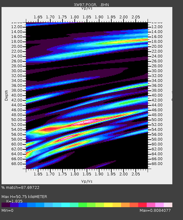
POGR XW.POGR - Earthquake Result Viewer
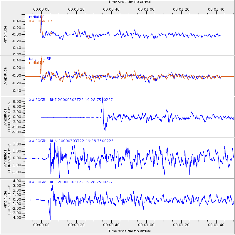
Earthquake location: Banda Sea
Earthquake latitude/longitude: -7.3/128.5
Earthquake time(UTC): 2000/03/03 (063) 22:09:13 GMT
Earthquake Depth: 142 km
Earthquake Magnitude: 6.4 MB, 5.8 MS, 6.3 MW, 6.3 MW
Earthquake Catalog/Contributor: WHDF/NEIC
Network: XW Tien Shan Continental Dynamics
Station: POGR XW.POGR
Lat/Lon: 41.02 N/75.55 E
Elevation: 2357 m
Distance: 68.3 deg
Az: 319.47 deg
Baz: 121.58 deg
Ray Param: 0.05600397
Estimated Moho Depth: 50.75 km
Estimated Crust Vp/Vs: 1.84
Assumed Crust Vp: 6.491 km/s
Estimated Crust Vs: 3.537 km/s
Estimated Crust Poisson's Ratio: 0.29
Radial Match: 87.69722 %
Radial Bump: 400
Transverse Match: 86.49694 %
Transverse Bump: 400
SOD ConfigId: 20082
Insert Time: 2010-02-26 15:45:45.243 +0000
GWidth: 2.5
Max Bumps: 400
Tol: 0.001

Signal To Noise

ChannelStoNSTALTA
XW:POGR: :BHN:20000303T22:19:28.750022Z3.08814574.9667113E-71.608315E-7
XW:POGR: :BHE:20000303T22:19:28.750022Z15.03595358.439109E-75.6126197E-8
XW:POGR: :BHZ:20000303T22:19:28.750022Z24.5098762.1963517E-68.961089E-8
Arrivals
Ps6.8 SECOND
PpPs21 SECOND
PsPs/PpSs28 SECOND