You are here: Home > Network List > XW97 - Tien Shan Continental Dynamics Stations List
> Station POGR XW.POGR > Earthquake Result Viewer
POGR XW.POGR - Earthquake Result Viewer
| Earthquake location: |
Northeast Of Taiwan |
| Earthquake latitude/longitude: |
26.1/124.5 |
| Earthquake time(UTC): |
2000/01/28 (028) 16:39:24 GMT |
| Earthquake Depth: |
194 km |
| Earthquake Magnitude: |
6.1 MB, 6.0 MW, 6.0 MW |
| Earthquake Catalog/Contributor: |
WHDF/NEIC |
|
| Network: |
XW Tien Shan Continental Dynamics |
| Station: |
POGR XW.POGR |
| Lat/Lon: |
41.02 N/75.55 E |
| Elevation: |
2357 m |
|
| Distance: |
42.9 deg |
| Az: |
303.013 deg |
| Baz: |
94.668 deg |
| Ray Param: |
0.07214249 |
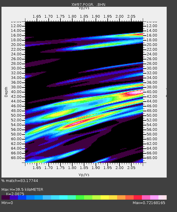
| Estimated Moho Depth: |
39.5 km |
| Estimated Crust Vp/Vs: |
2.09 |
| Assumed Crust Vp: |
6.491 km/s |
| Estimated Crust Vs: |
3.109 km/s |
| Estimated Crust Poisson's Ratio: |
0.35 |
|
| Radial Match: |
83.17744 % |
| Radial Bump: |
400 |
| Transverse Match: |
70.591034 % |
| Transverse Bump: |
400 |
| SOD ConfigId: |
20082 |
| Insert Time: |
2010-02-26 15:45:49.329 +0000 |
| GWidth: |
2.5 |
| Max Bumps: |
400 |
| Tol: |
0.001 |
|
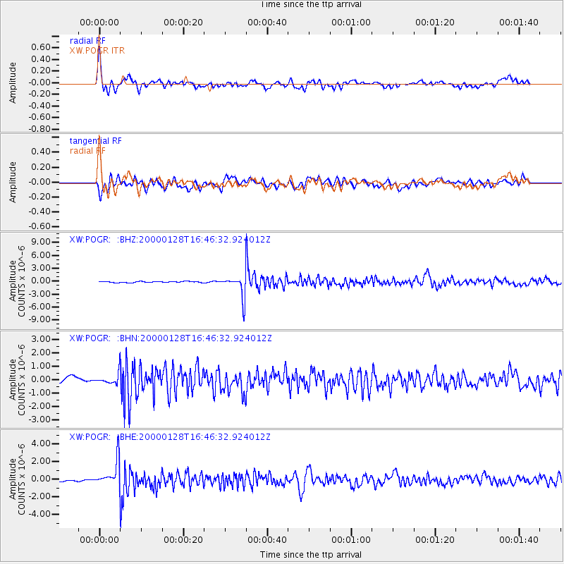
Signal To Noise
| Channel | StoN | STA | LTA |
| XW:POGR: :BHN:20000128T16:46:32.924012Z | 1.8796245 | 4.0364287E-7 | 2.1474656E-7 |
| XW:POGR: :BHE:20000128T16:46:32.924012Z | 16.530535 | 1.5356366E-6 | 9.289697E-8 |
| XW:POGR: :BHZ:20000128T16:46:32.924012Z | 20.751385 | 2.6580233E-6 | 1.2808897E-7 |
| Arrivals |
| Ps | 7.0 SECOND |
| PpPs | 18 SECOND |
| PsPs/PpSs | 25 SECOND |


