You are here: Home > Network List > IU - Global Seismograph Network (GSN - IRIS/USGS) Stations List
> Station PMG Port Moresby, New Guinea > Earthquake Result Viewer
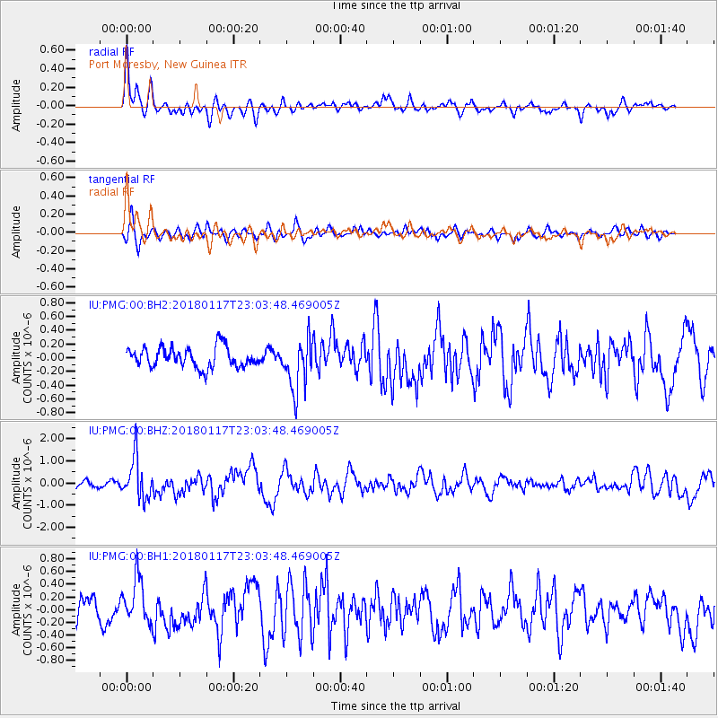
PMG Port Moresby, New Guinea - Earthquake Result Viewer
*The percent match for this event was below the threshold and hence no stack was calculated.
| Earthquake location: |
Kermadec Islands, New Zealand |
| Earthquake latitude/longitude: |
-30.1/-177.8 |
| Earthquake time(UTC): |
2018/01/17 (017) 22:56:58 GMT |
| Earthquake Depth: |
31 km |
| Earthquake Magnitude: |
5.8 mb |
| Earthquake Catalog/Contributor: |
NEIC PDE/us |
|
| Network: |
IU Global Seismograph Network (GSN - IRIS/USGS) |
| Station: |
PMG Port Moresby, New Guinea |
| Lat/Lon: |
9.40 S/147.16 E |
| Elevation: |
90 m |
|
| Distance: |
38.7 deg |
| Az: |
294.806 deg |
| Baz: |
127.125 deg |
| Ray Param: |
$rayparam |
*The percent match for this event was below the threshold and hence was not used in the summary stack. |
|
| Radial Match: |
71.966515 % |
| Radial Bump: |
400 |
| Transverse Match: |
64.03509 % |
| Transverse Bump: |
400 |
| SOD ConfigId: |
2546091 |
| Insert Time: |
2018-01-31 22:58:15.525 +0000 |
| GWidth: |
2.5 |
| Max Bumps: |
400 |
| Tol: |
0.001 |
|
Signal To Noise
| Channel | StoN | STA | LTA |
| IU:PMG:00:BHZ:20180117T23:03:48.469005Z | 6.7977366 | 9.378137E-7 | 1.379597E-7 |
| IU:PMG:00:BH1:20180117T23:03:48.469005Z | 1.7406766 | 3.583824E-7 | 2.0588683E-7 |
| IU:PMG:00:BH2:20180117T23:03:48.469005Z | 2.5372272 | 3.740632E-7 | 1.4742992E-7 |
| Arrivals |
| Ps | |
| PpPs | |
| PsPs/PpSs | |


