You are here: Home > Network List > US - United States National Seismic Network Stations List
> Station MNTX Cornudas Mountains, Texas, USA > Earthquake Result Viewer
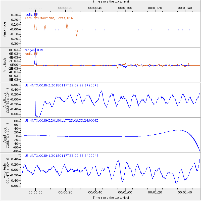
MNTX Cornudas Mountains, Texas, USA - Earthquake Result Viewer
*The percent match for this event was below the threshold and hence no stack was calculated.
| Earthquake location: |
Kermadec Islands, New Zealand |
| Earthquake latitude/longitude: |
-30.1/-177.8 |
| Earthquake time(UTC): |
2018/01/17 (017) 22:56:58 GMT |
| Earthquake Depth: |
31 km |
| Earthquake Magnitude: |
5.8 mb |
| Earthquake Catalog/Contributor: |
NEIC PDE/us |
|
| Network: |
US United States National Seismic Network |
| Station: |
MNTX Cornudas Mountains, Texas, USA |
| Lat/Lon: |
31.70 N/105.38 W |
| Elevation: |
404 m |
|
| Distance: |
92.1 deg |
| Az: |
54.387 deg |
| Baz: |
235.754 deg |
| Ray Param: |
$rayparam |
*The percent match for this event was below the threshold and hence was not used in the summary stack. |
|
| Radial Match: |
46.95092 % |
| Radial Bump: |
314 |
| Transverse Match: |
91.18544 % |
| Transverse Bump: |
115 |
| SOD ConfigId: |
2546091 |
| Insert Time: |
2018-01-31 22:59:11.536 +0000 |
| GWidth: |
2.5 |
| Max Bumps: |
400 |
| Tol: |
0.001 |
|
Signal To Noise
| Channel | StoN | STA | LTA |
| US:MNTX:00:BHZ:20180117T23:09:33.249004Z | 1.0934588 | 4.5241773E-5 | 4.1374922E-5 |
| US:MNTX:00:BH1:20180117T23:09:33.249004Z | 0.3509186 | 8.1421504E-8 | 2.3202391E-7 |
| US:MNTX:00:BH2:20180117T23:09:33.249004Z | 0.9290646 | 2.4557616E-7 | 2.6432625E-7 |
| Arrivals |
| Ps | |
| PpPs | |
| PsPs/PpSs | |


