You are here: Home > Network List > GM - US Geological Survey Networks Stations List
> Station IWM01 Jericho 2M Well Monitoring Station > Earthquake Result Viewer
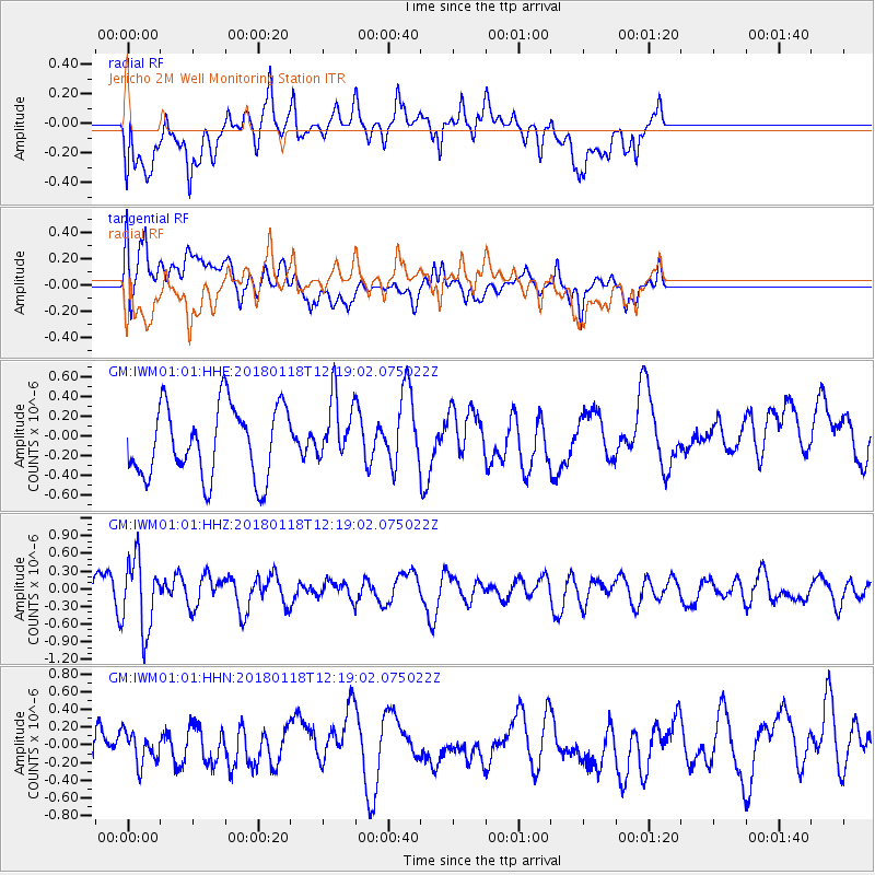
IWM01 Jericho 2M Well Monitoring Station - Earthquake Result Viewer
*The percent match for this event was below the threshold and hence no stack was calculated.
| Earthquake location: |
Northwest Of Kuril Islands |
| Earthquake latitude/longitude: |
52.6/153.0 |
| Earthquake time(UTC): |
2018/01/18 (018) 12:08:52 GMT |
| Earthquake Depth: |
448 km |
| Earthquake Magnitude: |
5.7 Mww |
| Earthquake Catalog/Contributor: |
NEIC PDE/us |
|
| Network: |
GM US Geological Survey Networks |
| Station: |
IWM01 Jericho 2M Well Monitoring Station |
| Lat/Lon: |
36.73 N/96.53 W |
| Elevation: |
328 m |
|
| Distance: |
72.5 deg |
| Az: |
52.085 deg |
| Baz: |
323.173 deg |
| Ray Param: |
$rayparam |
*The percent match for this event was below the threshold and hence was not used in the summary stack. |
|
| Radial Match: |
50.07043 % |
| Radial Bump: |
400 |
| Transverse Match: |
50.4737 % |
| Transverse Bump: |
400 |
| SOD ConfigId: |
2546091 |
| Insert Time: |
2018-02-01 12:09:58.172 +0000 |
| GWidth: |
2.5 |
| Max Bumps: |
400 |
| Tol: |
0.001 |
|
Signal To Noise
| Channel | StoN | STA | LTA |
| GM:IWM01:01:HHZ:20180118T12:19:02.075022Z | 2.6322553 | 6.051652E-7 | 2.2990369E-7 |
| GM:IWM01:01:HHN:20180118T12:19:02.075022Z | 0.65667486 | 1.7846273E-7 | 2.7176725E-7 |
| GM:IWM01:01:HHE:20180118T12:19:02.075022Z | 0.8985272 | 3.216905E-7 | 3.5801975E-7 |
| Arrivals |
| Ps | |
| PpPs | |
| PsPs/PpSs | |


