You are here: Home > Network List > IU - Global Seismograph Network (GSN - IRIS/USGS) Stations List
> Station RSSD Black Hills, South Dakota, USA > Earthquake Result Viewer
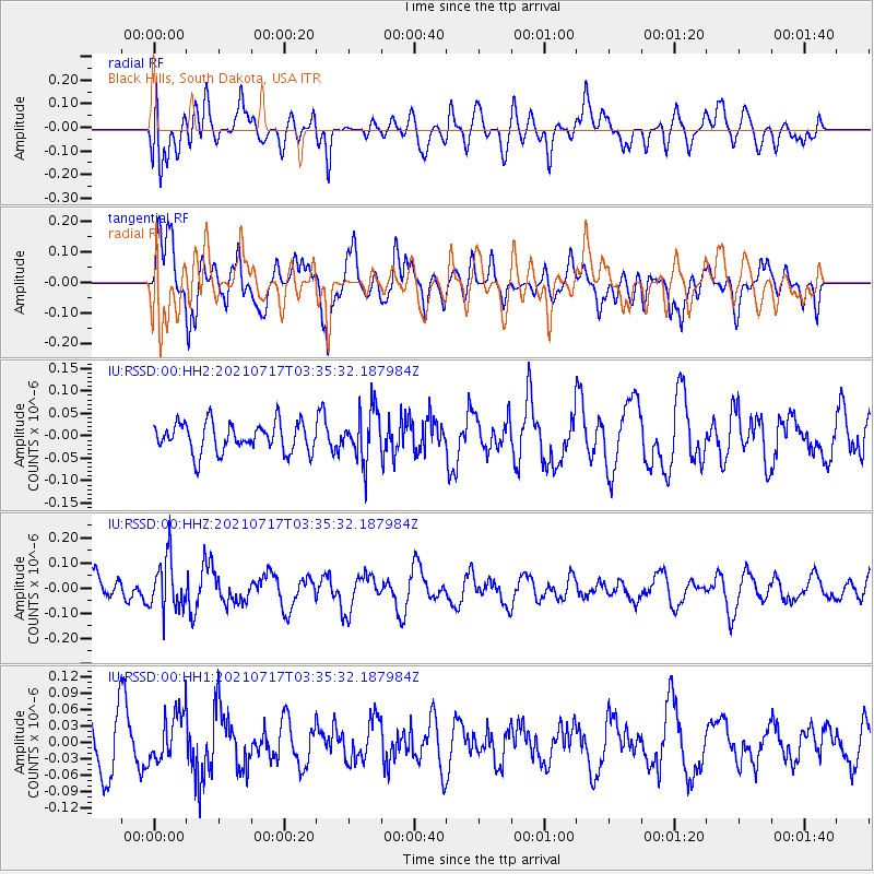
RSSD Black Hills, South Dakota, USA - Earthquake Result Viewer
*The percent match for this event was below the threshold and hence no stack was calculated.
| Earthquake location: |
Fiji Islands Region |
| Earthquake latitude/longitude: |
-20.6/-178.4 |
| Earthquake time(UTC): |
2021/07/17 (198) 03:23:47 GMT |
| Earthquake Depth: |
559 km |
| Earthquake Magnitude: |
5.5 Mww |
| Earthquake Catalog/Contributor: |
NEIC PDE/us |
|
| Network: |
IU Global Seismograph Network (GSN - IRIS/USGS) |
| Station: |
RSSD Black Hills, South Dakota, USA |
| Lat/Lon: |
44.12 N/104.04 W |
| Elevation: |
2090 m |
|
| Distance: |
93.5 deg |
| Az: |
44.009 deg |
| Baz: |
244.638 deg |
| Ray Param: |
$rayparam |
*The percent match for this event was below the threshold and hence was not used in the summary stack. |
|
| Radial Match: |
64.19299 % |
| Radial Bump: |
400 |
| Transverse Match: |
68.6618 % |
| Transverse Bump: |
400 |
| SOD ConfigId: |
25131211 |
| Insert Time: |
2021-07-31 03:37:44.628 +0000 |
| GWidth: |
2.5 |
| Max Bumps: |
400 |
| Tol: |
0.001 |
|
Signal To Noise
| Channel | StoN | STA | LTA |
| IU:RSSD:00:HHZ:20210717T03:35:32.187984Z | 1.9609091 | 1.0398451E-7 | 5.3028728E-8 |
| IU:RSSD:00:HH1:20210717T03:35:32.187984Z | 1.2390064 | 4.5536073E-8 | 3.6752088E-8 |
| IU:RSSD:00:HH2:20210717T03:35:32.187984Z | 1.7877148 | 5.8554075E-8 | 3.2753587E-8 |
| Arrivals |
| Ps | |
| PpPs | |
| PsPs/PpSs | |


