You are here: Home > Network List > TA - USArray Transportable Network (new EarthScope stations) Stations List
> Station POKR Poker Plat Research Range, AK, USA > Earthquake Result Viewer
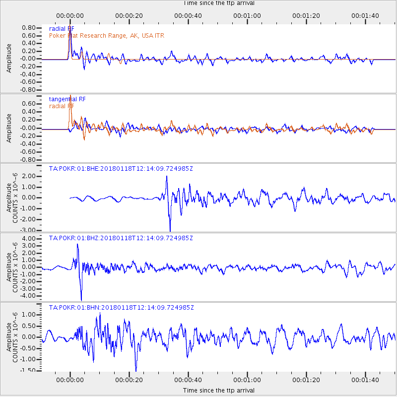
POKR Poker Plat Research Range, AK, USA - Earthquake Result Viewer
*The percent match for this event was below the threshold and hence no stack was calculated.
| Earthquake location: |
Northwest Of Kuril Islands |
| Earthquake latitude/longitude: |
52.6/153.0 |
| Earthquake time(UTC): |
2018/01/18 (018) 12:08:52 GMT |
| Earthquake Depth: |
448 km |
| Earthquake Magnitude: |
5.7 Mww |
| Earthquake Catalog/Contributor: |
NEIC PDE/us |
|
| Network: |
TA USArray Transportable Network (new EarthScope stations) |
| Station: |
POKR Poker Plat Research Range, AK, USA |
| Lat/Lon: |
65.12 N/147.43 W |
| Elevation: |
501 m |
|
| Distance: |
32.0 deg |
| Az: |
43.579 deg |
| Baz: |
275.979 deg |
| Ray Param: |
$rayparam |
*The percent match for this event was below the threshold and hence was not used in the summary stack. |
|
| Radial Match: |
68.68079 % |
| Radial Bump: |
379 |
| Transverse Match: |
48.235504 % |
| Transverse Bump: |
361 |
| SOD ConfigId: |
2546091 |
| Insert Time: |
2018-02-01 12:11:47.040 +0000 |
| GWidth: |
2.5 |
| Max Bumps: |
400 |
| Tol: |
0.001 |
|
Signal To Noise
| Channel | StoN | STA | LTA |
| TA:POKR:01:BHZ:20180118T12:14:09.724985Z | 8.309804 | 1.5973601E-6 | 1.9222598E-7 |
| TA:POKR:01:BHN:20180118T12:14:09.724985Z | 1.0169919 | 2.366222E-7 | 2.3266873E-7 |
| TA:POKR:01:BHE:20180118T12:14:09.724985Z | 7.1310596 | 9.808357E-7 | 1.3754418E-7 |
| Arrivals |
| Ps | |
| PpPs | |
| PsPs/PpSs | |


