You are here: Home > Network List > US - United States National Seismic Network Stations List
> Station EGMT Eagleton, Montana, USA > Earthquake Result Viewer
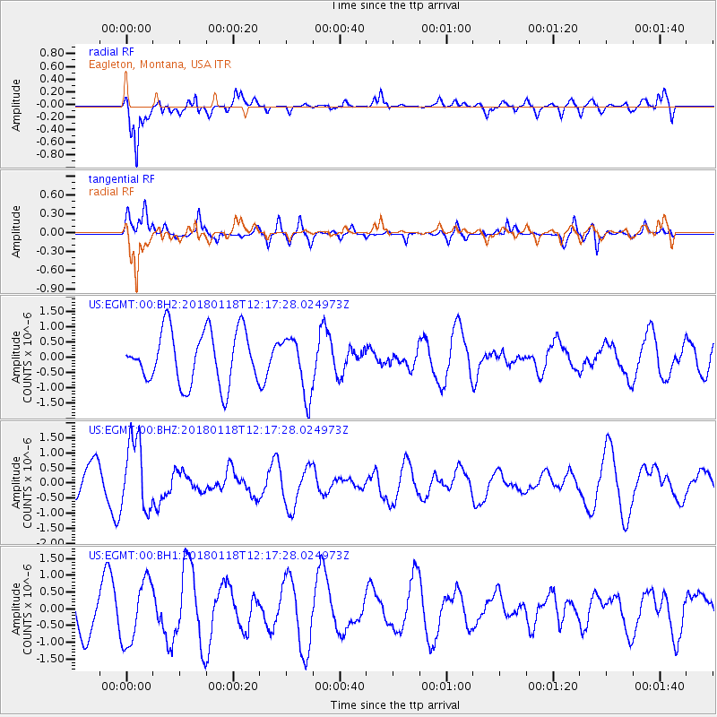
EGMT Eagleton, Montana, USA - Earthquake Result Viewer
*The percent match for this event was below the threshold and hence no stack was calculated.
| Earthquake location: |
Northwest Of Kuril Islands |
| Earthquake latitude/longitude: |
52.6/153.0 |
| Earthquake time(UTC): |
2018/01/18 (018) 12:08:52 GMT |
| Earthquake Depth: |
448 km |
| Earthquake Magnitude: |
5.7 Mww |
| Earthquake Catalog/Contributor: |
NEIC PDE/us |
|
| Network: |
US United States National Seismic Network |
| Station: |
EGMT Eagleton, Montana, USA |
| Lat/Lon: |
48.02 N/109.75 W |
| Elevation: |
1055 m |
|
| Distance: |
57.6 deg |
| Az: |
52.031 deg |
| Baz: |
314.205 deg |
| Ray Param: |
$rayparam |
*The percent match for this event was below the threshold and hence was not used in the summary stack. |
|
| Radial Match: |
80.68235 % |
| Radial Bump: |
400 |
| Transverse Match: |
66.7236 % |
| Transverse Bump: |
400 |
| SOD ConfigId: |
2546091 |
| Insert Time: |
2018-02-01 12:12:38.197 +0000 |
| GWidth: |
2.5 |
| Max Bumps: |
400 |
| Tol: |
0.001 |
|
Signal To Noise
| Channel | StoN | STA | LTA |
| US:EGMT:00:BHZ:20180118T12:17:28.024973Z | 1.8670791 | 1.1772763E-6 | 6.305444E-7 |
| US:EGMT:00:BH1:20180118T12:17:28.024973Z | 1.1871034 | 9.3525193E-7 | 7.878437E-7 |
| US:EGMT:00:BH2:20180118T12:17:28.024973Z | 1.1066158 | 9.5365806E-7 | 8.617788E-7 |
| Arrivals |
| Ps | |
| PpPs | |
| PsPs/PpSs | |


