You are here: Home > Network List > US - United States National Seismic Network Stations List
> Station HAWA Hanford, Washington, USA > Earthquake Result Viewer
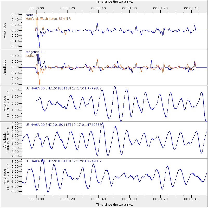
HAWA Hanford, Washington, USA - Earthquake Result Viewer
*The percent match for this event was below the threshold and hence no stack was calculated.
| Earthquake location: |
Northwest Of Kuril Islands |
| Earthquake latitude/longitude: |
52.6/153.0 |
| Earthquake time(UTC): |
2018/01/18 (018) 12:08:52 GMT |
| Earthquake Depth: |
448 km |
| Earthquake Magnitude: |
5.7 Mww |
| Earthquake Catalog/Contributor: |
NEIC PDE/us |
|
| Network: |
US United States National Seismic Network |
| Station: |
HAWA Hanford, Washington, USA |
| Lat/Lon: |
46.39 N/119.53 W |
| Elevation: |
364 m |
|
| Distance: |
53.8 deg |
| Az: |
58.935 deg |
| Baz: |
310.936 deg |
| Ray Param: |
$rayparam |
*The percent match for this event was below the threshold and hence was not used in the summary stack. |
|
| Radial Match: |
68.532715 % |
| Radial Bump: |
366 |
| Transverse Match: |
45.164215 % |
| Transverse Bump: |
400 |
| SOD ConfigId: |
2546091 |
| Insert Time: |
2018-02-01 12:12:42.138 +0000 |
| GWidth: |
2.5 |
| Max Bumps: |
400 |
| Tol: |
0.001 |
|
Signal To Noise
| Channel | StoN | STA | LTA |
| US:HAWA:00:BHZ:20180118T12:17:01.474985Z | 0.72089034 | 1.0121594E-6 | 1.4040407E-6 |
| US:HAWA:00:BH1:20180118T12:17:01.474985Z | 2.969298 | 2.4599524E-6 | 8.2846265E-7 |
| US:HAWA:00:BH2:20180118T12:17:01.474985Z | 0.9055539 | 5.2611887E-7 | 5.809913E-7 |
| Arrivals |
| Ps | |
| PpPs | |
| PsPs/PpSs | |


