You are here: Home > Network List > US - United States National Seismic Network Stations List
> Station OGNE Ogallala, Nebraska, USA > Earthquake Result Viewer
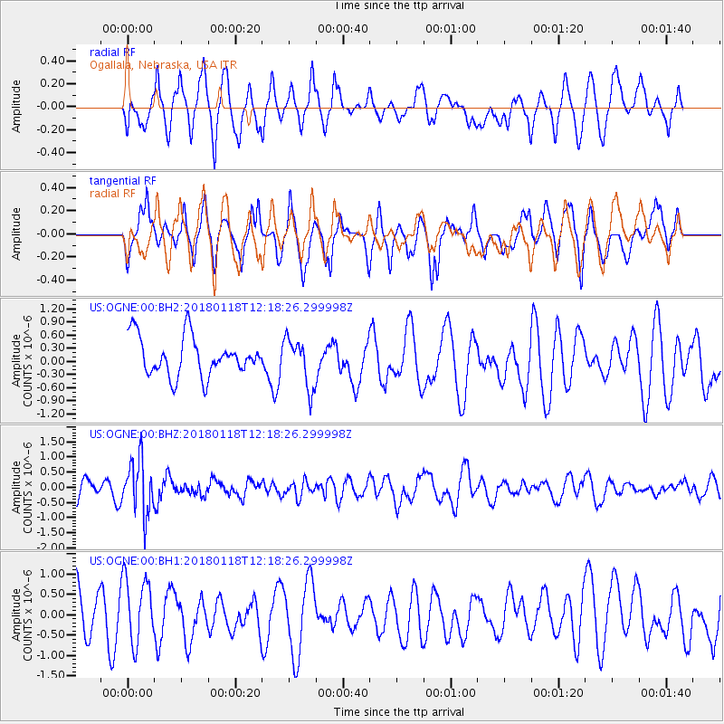
OGNE Ogallala, Nebraska, USA - Earthquake Result Viewer
*The percent match for this event was below the threshold and hence no stack was calculated.
| Earthquake location: |
Northwest Of Kuril Islands |
| Earthquake latitude/longitude: |
52.6/153.0 |
| Earthquake time(UTC): |
2018/01/18 (018) 12:08:52 GMT |
| Earthquake Depth: |
448 km |
| Earthquake Magnitude: |
5.7 Mww |
| Earthquake Catalog/Contributor: |
NEIC PDE/us |
|
| Network: |
US United States National Seismic Network |
| Station: |
OGNE Ogallala, Nebraska, USA |
| Lat/Lon: |
40.95 N/102.03 W |
| Elevation: |
1054 m |
|
| Distance: |
66.6 deg |
| Az: |
52.888 deg |
| Baz: |
320.014 deg |
| Ray Param: |
$rayparam |
*The percent match for this event was below the threshold and hence was not used in the summary stack. |
|
| Radial Match: |
54.514545 % |
| Radial Bump: |
400 |
| Transverse Match: |
47.887985 % |
| Transverse Bump: |
306 |
| SOD ConfigId: |
2546091 |
| Insert Time: |
2018-02-01 12:12:56.247 +0000 |
| GWidth: |
2.5 |
| Max Bumps: |
400 |
| Tol: |
0.001 |
|
Signal To Noise
| Channel | StoN | STA | LTA |
| US:OGNE:00:BHZ:20180118T12:18:26.299998Z | 3.2742534 | 8.8715683E-7 | 2.7094936E-7 |
| US:OGNE:00:BH1:20180118T12:18:26.299998Z | 1.1722388 | 8.3303206E-7 | 7.106334E-7 |
| US:OGNE:00:BH2:20180118T12:18:26.299998Z | 1.280845 | 5.632745E-7 | 4.397679E-7 |
| Arrivals |
| Ps | |
| PpPs | |
| PsPs/PpSs | |


