You are here: Home > Network List > AK - Alaska Regional Network Stations List
> Station L20K Alaska Regional Network > Earthquake Result Viewer
L20K Alaska Regional Network - Earthquake Result Viewer
| Earthquake location: |
South Of Panama |
| Earthquake latitude/longitude: |
6.8/-82.7 |
| Earthquake time(UTC): |
2021/07/17 (198) 20:56:10 GMT |
| Earthquake Depth: |
4.1 km |
| Earthquake Magnitude: |
6.1 mww |
| Earthquake Catalog/Contributor: |
NEIC PDE/us |
|
| Network: |
AK Alaska Regional Network |
| Station: |
L20K Alaska Regional Network |
| Lat/Lon: |
62.48 N/153.88 W |
| Elevation: |
673 m |
|
| Distance: |
75.3 deg |
| Az: |
332.964 deg |
| Baz: |
103.663 deg |
| Ray Param: |
0.05175442 |
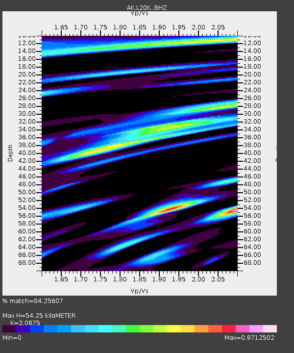
| Estimated Moho Depth: |
54.25 km |
| Estimated Crust Vp/Vs: |
2.10 |
| Assumed Crust Vp: |
6.566 km/s |
| Estimated Crust Vs: |
3.13 km/s |
| Estimated Crust Poisson's Ratio: |
0.35 |
|
| Radial Match: |
84.25607 % |
| Radial Bump: |
400 |
| Transverse Match: |
77.66494 % |
| Transverse Bump: |
400 |
| SOD ConfigId: |
25131211 |
| Insert Time: |
2021-07-31 20:59:37.479 +0000 |
| GWidth: |
2.5 |
| Max Bumps: |
400 |
| Tol: |
0.001 |
|

Signal To Noise
| Channel | StoN | STA | LTA |
| AK:L20K: :BHZ:20210717T21:07:23.159979Z | 11.672501 | 5.6995924E-7 | 4.8829232E-8 |
| AK:L20K: :BHN:20210717T21:07:23.159979Z | 1.4050231 | 5.6671862E-8 | 4.0335184E-8 |
| AK:L20K: :BHE:20210717T21:07:23.159979Z | 4.4465647 | 1.821182E-7 | 4.0957058E-8 |
| Arrivals |
| Ps | 9.3 SECOND |
| PpPs | 25 SECOND |
| PsPs/PpSs | 34 SECOND |


