You are here: Home > Network List > AV - Alaska Volcano Observatory Stations List
> Station MNAT Nateekin Bay, Makushin Volcano, Alaska > Earthquake Result Viewer
MNAT Nateekin Bay, Makushin Volcano, Alaska - Earthquake Result Viewer
| Earthquake location: |
South Of Panama |
| Earthquake latitude/longitude: |
6.8/-82.7 |
| Earthquake time(UTC): |
2021/07/17 (198) 20:56:10 GMT |
| Earthquake Depth: |
4.1 km |
| Earthquake Magnitude: |
6.1 mww |
| Earthquake Catalog/Contributor: |
NEIC PDE/us |
|
| Network: |
AV Alaska Volcano Observatory |
| Station: |
MNAT Nateekin Bay, Makushin Volcano, Alaska |
| Lat/Lon: |
53.88 N/166.69 W |
| Elevation: |
390 m |
|
| Distance: |
81.0 deg |
| Az: |
323.407 deg |
| Baz: |
90.791 deg |
| Ray Param: |
0.047910366 |
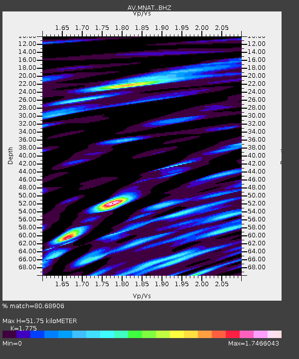
| Estimated Moho Depth: |
51.75 km |
| Estimated Crust Vp/Vs: |
1.77 |
| Assumed Crust Vp: |
3.943 km/s |
| Estimated Crust Vs: |
2.222 km/s |
| Estimated Crust Poisson's Ratio: |
0.27 |
|
| Radial Match: |
80.68906 % |
| Radial Bump: |
400 |
| Transverse Match: |
58.750378 % |
| Transverse Bump: |
400 |
| SOD ConfigId: |
25131211 |
| Insert Time: |
2021-07-31 21:02:48.663 +0000 |
| GWidth: |
2.5 |
| Max Bumps: |
400 |
| Tol: |
0.001 |
|
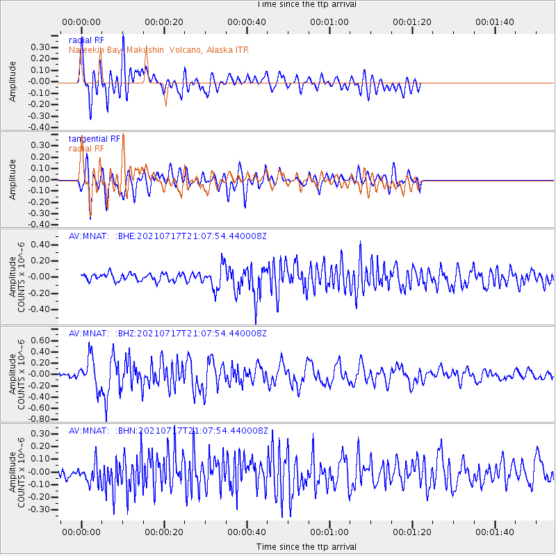
Signal To Noise
| Channel | StoN | STA | LTA |
| AV:MNAT: :BHZ:20210717T21:07:54.440008Z | 6.327704 | 2.6995474E-7 | 4.2662354E-8 |
| AV:MNAT: :BHN:20210717T21:07:54.440008Z | 1.2499181 | 8.435859E-8 | 6.749129E-8 |
| AV:MNAT: :BHE:20210717T21:07:54.440008Z | 3.2885153 | 1.42647E-7 | 4.3377323E-8 |
| Arrivals |
| Ps | 10 SECOND |
| PpPs | 36 SECOND |
| PsPs/PpSs | 46 SECOND |


