You are here: Home > Network List > KZ - Kazakhstan Network Stations List
> Station VOS Vostochnoye, Kazakstan > Earthquake Result Viewer
VOS Vostochnoye, Kazakstan - Earthquake Result Viewer
| Earthquake location: |
East Of Kuril Islands |
| Earthquake latitude/longitude: |
44.0/151.4 |
| Earthquake time(UTC): |
2004/09/13 (257) 03:00:12 GMT |
| Earthquake Depth: |
8.0 km |
| Earthquake Magnitude: |
6.0 MB, 5.4 MS, 6.1 MW, 5.9 MW |
| Earthquake Catalog/Contributor: |
WHDF/NEIC |
|
| Network: |
KZ Kazakhstan Network |
| Station: |
VOS Vostochnoye, Kazakstan |
| Lat/Lon: |
52.72 N/70.98 E |
| Elevation: |
300 m |
|
| Distance: |
51.5 deg |
| Az: |
309.976 deg |
| Baz: |
65.402 deg |
| Ray Param: |
0.06737677 |
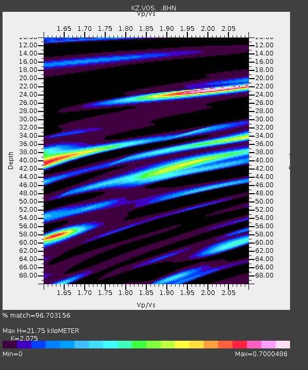
| Estimated Moho Depth: |
21.75 km |
| Estimated Crust Vp/Vs: |
2.08 |
| Assumed Crust Vp: |
6.552 km/s |
| Estimated Crust Vs: |
3.158 km/s |
| Estimated Crust Poisson's Ratio: |
0.35 |
|
| Radial Match: |
96.703156 % |
| Radial Bump: |
315 |
| Transverse Match: |
86.98406 % |
| Transverse Bump: |
400 |
| SOD ConfigId: |
2459 |
| Insert Time: |
2010-03-09 10:29:45.049 +0000 |
| GWidth: |
2.5 |
| Max Bumps: |
400 |
| Tol: |
0.001 |
|

Signal To Noise
| Channel | StoN | STA | LTA |
| KZ:VOS: :BHN:20040913T03:08:47.894006Z | 6.451641 | 6.6244365E-7 | 1.02678314E-7 |
| KZ:VOS: :BHE:20040913T03:08:47.894006Z | 17.57357 | 1.5399784E-6 | 8.763036E-8 |
| KZ:VOS: :BHZ:20040913T03:08:47.894006Z | 22.099424 | 2.4026544E-6 | 1.0872023E-7 |
| Arrivals |
| Ps | 3.8 SECOND |
| PpPs | 9.7 SECOND |
| PsPs/PpSs | 13 SECOND |


