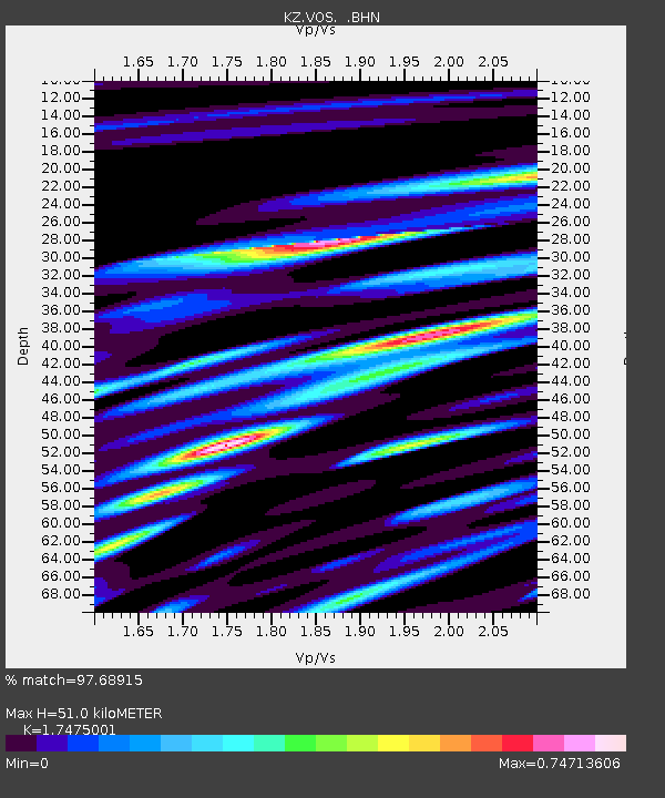
VOS Vostochnoye, Kazakstan - Earthquake Result Viewer

Earthquake location: South Of Aleutian Islands
Earthquake latitude/longitude: 51.8/-166.3
Earthquake time(UTC): 2004/08/07 (220) 09:30:16 GMT
Earthquake Depth: 8.0 km
Earthquake Magnitude: 6.3 MB, 5.4 MS, 6.0 MW, 6.0 MW
Earthquake Catalog/Contributor: WHDF/NEIC
Network: KZ Kazakhstan Network
Station: VOS Vostochnoye, Kazakstan
Lat/Lon: 52.72 N/70.98 E
Elevation: 300 m
Distance: 65.3 deg
Az: 325.721 deg
Baz: 35.142 deg
Ray Param: 0.058350004
Estimated Moho Depth: 51.0 km
Estimated Crust Vp/Vs: 1.75
Assumed Crust Vp: 6.552 km/s
Estimated Crust Vs: 3.75 km/s
Estimated Crust Poisson's Ratio: 0.26
Radial Match: 97.68915 %
Radial Bump: 345
Transverse Match: 90.91259 %
Transverse Bump: 400
SOD ConfigId: 2459
Insert Time: 2010-03-09 10:29:50.940 +0000
GWidth: 2.5
Max Bumps: 400
Tol: 0.001

Signal To Noise

ChannelStoNSTALTA
KZ:VOS: :BHN:20040807T09:40:28.265012Z25.7549515.5639174E-72.1603292E-8
KZ:VOS: :BHE:20040807T09:40:28.265012Z27.6263685.035565E-71.8227388E-8
KZ:VOS: :BHZ:20040807T09:40:28.265012Z35.108831.2331487E-63.5123605E-8
Arrivals
Ps6.1 SECOND
PpPs20 SECOND
PsPs/PpSs27 SECOND