You are here: Home > Network List > IU - Global Seismograph Network (GSN - IRIS/USGS) Stations List
> Station JOHN Johnston Island, USA > Earthquake Result Viewer
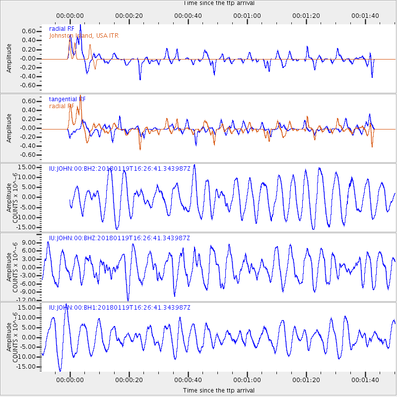
JOHN Johnston Island, USA - Earthquake Result Viewer
*The percent match for this event was below the threshold and hence no stack was calculated.
| Earthquake location: |
Gulf Of California |
| Earthquake latitude/longitude: |
26.7/-111.1 |
| Earthquake time(UTC): |
2018/01/19 (019) 16:17:42 GMT |
| Earthquake Depth: |
10 km |
| Earthquake Magnitude: |
6.3 Mww |
| Earthquake Catalog/Contributor: |
NEIC PDE/us |
|
| Network: |
IU Global Seismograph Network (GSN - IRIS/USGS) |
| Station: |
JOHN Johnston Island, USA |
| Lat/Lon: |
16.73 N/169.53 W |
| Elevation: |
2.0 m |
|
| Distance: |
54.8 deg |
| Az: |
272.241 deg |
| Baz: |
68.918 deg |
| Ray Param: |
$rayparam |
*The percent match for this event was below the threshold and hence was not used in the summary stack. |
|
| Radial Match: |
70.485695 % |
| Radial Bump: |
400 |
| Transverse Match: |
58.462173 % |
| Transverse Bump: |
360 |
| SOD ConfigId: |
2546091 |
| Insert Time: |
2018-02-02 16:18:59.213 +0000 |
| GWidth: |
2.5 |
| Max Bumps: |
400 |
| Tol: |
0.001 |
|
Signal To Noise
| Channel | StoN | STA | LTA |
| IU:JOHN:00:BHZ:20180119T16:26:41.343987Z | 0.45319134 | 3.3449821E-6 | 7.380949E-6 |
| IU:JOHN:00:BH1:20180119T16:26:41.343987Z | 1.8707412 | 7.301577E-6 | 3.9030397E-6 |
| IU:JOHN:00:BH2:20180119T16:26:41.343987Z | 0.6887462 | 4.913815E-6 | 7.134435E-6 |
| Arrivals |
| Ps | |
| PpPs | |
| PsPs/PpSs | |


