You are here: Home > Network List > US - United States National Seismic Network Stations List
> Station LONY Lake Ozonia, New York, USA > Earthquake Result Viewer
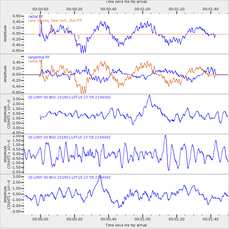
LONY Lake Ozonia, New York, USA - Earthquake Result Viewer
*The percent match for this event was below the threshold and hence no stack was calculated.
| Earthquake location: |
Gulf Of California |
| Earthquake latitude/longitude: |
26.7/-111.1 |
| Earthquake time(UTC): |
2018/01/19 (019) 16:17:42 GMT |
| Earthquake Depth: |
10 km |
| Earthquake Magnitude: |
6.3 Mww |
| Earthquake Catalog/Contributor: |
NEIC PDE/us |
|
| Network: |
US United States National Seismic Network |
| Station: |
LONY Lake Ozonia, New York, USA |
| Lat/Lon: |
44.62 N/74.58 W |
| Elevation: |
440 m |
|
| Distance: |
34.3 deg |
| Az: |
48.958 deg |
| Baz: |
250.902 deg |
| Ray Param: |
$rayparam |
*The percent match for this event was below the threshold and hence was not used in the summary stack. |
|
| Radial Match: |
49.976875 % |
| Radial Bump: |
400 |
| Transverse Match: |
39.106895 % |
| Transverse Bump: |
400 |
| SOD ConfigId: |
2546091 |
| Insert Time: |
2018-02-02 16:19:56.094 +0000 |
| GWidth: |
2.5 |
| Max Bumps: |
400 |
| Tol: |
0.001 |
|
Signal To Noise
| Channel | StoN | STA | LTA |
| US:LONY:00:BHZ:20180119T16:23:58.224999Z | 2.5791745 | 9.1012686E-7 | 3.5287525E-7 |
| US:LONY:00:BH1:20180119T16:23:58.224999Z | 1.1278763 | 5.868928E-7 | 5.203521E-7 |
| US:LONY:00:BH2:20180119T16:23:58.224999Z | 1.015479 | 4.0648072E-7 | 4.0028473E-7 |
| Arrivals |
| Ps | |
| PpPs | |
| PsPs/PpSs | |


