You are here: Home > Network List > GM - US Geological Survey Networks Stations List
> Station NMP41 New Mexico Permian - Site# W4S1 > Earthquake Result Viewer
NMP41 New Mexico Permian - Site# W4S1 - Earthquake Result Viewer
| Earthquake location: |
South Of Panama |
| Earthquake latitude/longitude: |
6.8/-82.7 |
| Earthquake time(UTC): |
2021/07/17 (198) 20:56:10 GMT |
| Earthquake Depth: |
4.1 km |
| Earthquake Magnitude: |
6.1 mww |
| Earthquake Catalog/Contributor: |
NEIC PDE/us |
|
| Network: |
GM US Geological Survey Networks |
| Station: |
NMP41 New Mexico Permian - Site# W4S1 |
| Lat/Lon: |
32.01 N/103.60 W |
| Elevation: |
960 m |
|
| Distance: |
31.8 deg |
| Az: |
324.802 deg |
| Baz: |
137.646 deg |
| Ray Param: |
0.0789651 |
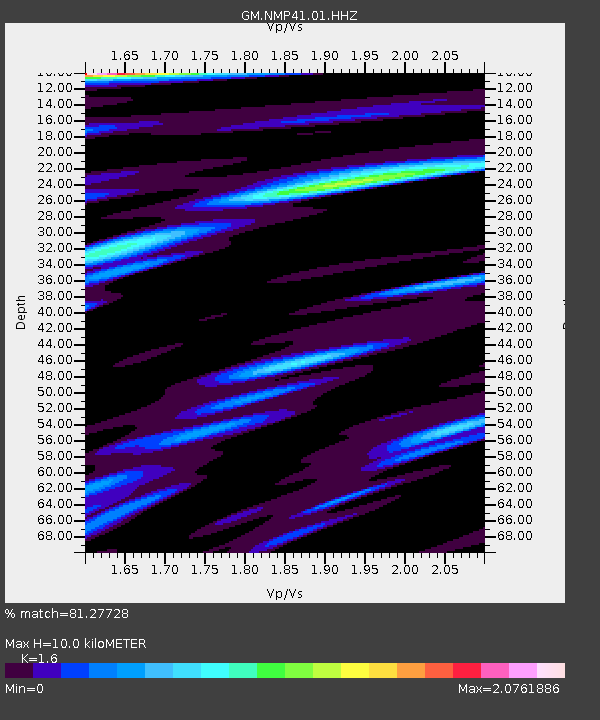
| Estimated Moho Depth: |
10.0 km |
| Estimated Crust Vp/Vs: |
1.60 |
| Assumed Crust Vp: |
6.129 km/s |
| Estimated Crust Vs: |
3.831 km/s |
| Estimated Crust Poisson's Ratio: |
0.18 |
|
| Radial Match: |
81.27728 % |
| Radial Bump: |
400 |
| Transverse Match: |
71.417694 % |
| Transverse Bump: |
400 |
| SOD ConfigId: |
25131211 |
| Insert Time: |
2021-07-31 21:13:21.849 +0000 |
| GWidth: |
2.5 |
| Max Bumps: |
400 |
| Tol: |
0.001 |
|

Signal To Noise
| Channel | StoN | STA | LTA |
| GM:NMP41:01:HHZ:20210717T21:02:04.495Z | 22.37706 | 1.7333916E-6 | 7.7462886E-8 |
| GM:NMP41:01:HHN:20210717T21:02:04.495Z | 6.815271 | 7.7696376E-7 | 1.14003356E-7 |
| GM:NMP41:01:HHE:20210717T21:02:04.495Z | 6.431416 | 9.0760244E-7 | 1.4112015E-7 |
| Arrivals |
| Ps | 1.1 SECOND |
| PpPs | 3.9 SECOND |
| PsPs/PpSs | 5.0 SECOND |


