You are here: Home > Network List > GS - US Geological Survey Networks Stations List
> Station ASA6 ASA6 > Earthquake Result Viewer
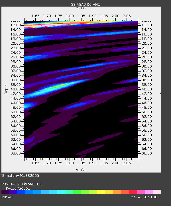
ASA6 ASA6 - Earthquake Result Viewer
| Earthquake location: |
South Of Panama |
| Earthquake latitude/longitude: |
6.8/-82.7 |
| Earthquake time(UTC): |
2021/07/17 (198) 20:56:10 GMT |
| Earthquake Depth: |
4.1 km |
| Earthquake Magnitude: |
6.1 mww |
| Earthquake Catalog/Contributor: |
NEIC PDE/us |
|
| Network: |
GS US Geological Survey Networks |
| Station: |
ASA6 ASA6 |
| Lat/Lon: |
34.94 N/106.46 W |
| Elevation: |
1840 m |
|
| Distance: |
35.5 deg |
| Az: |
325.247 deg |
| Baz: |
136.446 deg |
| Ray Param: |
0.077191584 |
| Estimated Moho Depth: |
12.0 km |
| Estimated Crust Vp/Vs: |
1.68 |
| Assumed Crust Vp: |
6.502 km/s |
| Estimated Crust Vs: |
3.882 km/s |
| Estimated Crust Poisson's Ratio: |
0.22 |
|
| Radial Match: |
91.382965 % |
| Radial Bump: |
400 |
| Transverse Match: |
77.78882 % |
| Transverse Bump: |
400 |
| SOD ConfigId: |
25131211 |
| Insert Time: |
2021-07-31 21:13:42.976 +0000 |
| GWidth: |
2.5 |
| Max Bumps: |
400 |
| Tol: |
0.001 |
|

Signal To Noise
| Channel | StoN | STA | LTA |
| GS:ASA6:00:HHZ:20210717T21:02:37.248998Z | 31.647017 | 2.477344E-6 | 7.8280486E-8 |
| GS:ASA6:00:HH1:20210717T21:02:37.248998Z | 32.12984 | 1.3801983E-6 | 4.2956895E-8 |
| GS:ASA6:00:HH2:20210717T21:02:37.248998Z | 24.768599 | 1.1208891E-6 | 4.5254446E-8 |
| Arrivals |
| Ps | 1.4 SECOND |
| PpPs | 4.5 SECOND |
| PsPs/PpSs | 5.9 SECOND |


