You are here: Home > Network List > GS - US Geological Survey Networks Stations List
> Station DEC04 Decatur Surface Seismic Site, Decatur, IL, USA > Earthquake Result Viewer
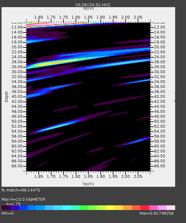
DEC04 Decatur Surface Seismic Site, Decatur, IL, USA - Earthquake Result Viewer
| Earthquake location: |
South Of Panama |
| Earthquake latitude/longitude: |
6.8/-82.7 |
| Earthquake time(UTC): |
2021/07/17 (198) 20:56:10 GMT |
| Earthquake Depth: |
4.1 km |
| Earthquake Magnitude: |
6.1 mww |
| Earthquake Catalog/Contributor: |
NEIC PDE/us |
|
| Network: |
GS US Geological Survey Networks |
| Station: |
DEC04 Decatur Surface Seismic Site, Decatur, IL, USA |
| Lat/Lon: |
39.88 N/88.86 W |
| Elevation: |
225 m |
|
| Distance: |
33.4 deg |
| Az: |
351.336 deg |
| Baz: |
168.791 deg |
| Ray Param: |
0.078262806 |
| Estimated Moho Depth: |
10.0 km |
| Estimated Crust Vp/Vs: |
1.75 |
| Assumed Crust Vp: |
6.444 km/s |
| Estimated Crust Vs: |
3.682 km/s |
| Estimated Crust Poisson's Ratio: |
0.26 |
|
| Radial Match: |
86.14475 % |
| Radial Bump: |
400 |
| Transverse Match: |
23.346394 % |
| Transverse Bump: |
400 |
| SOD ConfigId: |
25131211 |
| Insert Time: |
2021-07-31 21:13:46.428 +0000 |
| GWidth: |
2.5 |
| Max Bumps: |
400 |
| Tol: |
0.001 |
|

Signal To Noise
| Channel | StoN | STA | LTA |
| GS:DEC04:01:HHZ:20210717T21:02:18.649999Z | 11.280523 | 1.711812E-6 | 1.5174935E-7 |
| GS:DEC04:01:HHN:20210717T21:02:18.649999Z | 2.1627045 | 1.1390184E-6 | 5.266639E-7 |
| GS:DEC04:01:HHE:20210717T21:02:18.649999Z | 1.302964 | 8.300092E-7 | 6.370162E-7 |
| Arrivals |
| Ps | 1.3 SECOND |
| PpPs | 3.9 SECOND |
| PsPs/PpSs | 5.2 SECOND |


