You are here: Home > Network List > IW - Intermountain West Stations List
> Station DLMT Dillon, Montana, USA > Earthquake Result Viewer
DLMT Dillon, Montana, USA - Earthquake Result Viewer
| Earthquake location: |
South Of Panama |
| Earthquake latitude/longitude: |
6.8/-82.7 |
| Earthquake time(UTC): |
2021/07/17 (198) 20:56:10 GMT |
| Earthquake Depth: |
4.1 km |
| Earthquake Magnitude: |
6.1 mww |
| Earthquake Catalog/Contributor: |
NEIC PDE/us |
|
| Network: |
IW Intermountain West |
| Station: |
DLMT Dillon, Montana, USA |
| Lat/Lon: |
45.36 N/112.60 W |
| Elevation: |
1569 m |
|
| Distance: |
46.3 deg |
| Az: |
330.913 deg |
| Baz: |
136.785 deg |
| Ray Param: |
0.07074136 |
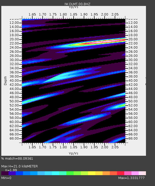
| Estimated Moho Depth: |
21.0 km |
| Estimated Crust Vp/Vs: |
1.99 |
| Assumed Crust Vp: |
6.577 km/s |
| Estimated Crust Vs: |
3.305 km/s |
| Estimated Crust Poisson's Ratio: |
0.33 |
|
| Radial Match: |
88.09361 % |
| Radial Bump: |
400 |
| Transverse Match: |
77.83833 % |
| Transverse Bump: |
400 |
| SOD ConfigId: |
25131211 |
| Insert Time: |
2021-07-31 21:15:00.212 +0000 |
| GWidth: |
2.5 |
| Max Bumps: |
400 |
| Tol: |
0.001 |
|
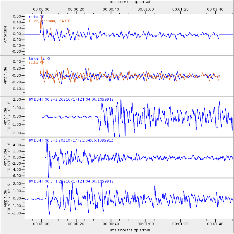
Signal To Noise
| Channel | StoN | STA | LTA |
| IW:DLMT:00:BHZ:20210717T21:04:06.109991Z | 61.676388 | 2.4691178E-6 | 4.0033438E-8 |
| IW:DLMT:00:BH1:20210717T21:04:06.109991Z | 13.190286 | 8.4590965E-7 | 6.4131264E-8 |
| IW:DLMT:00:BH2:20210717T21:04:06.109991Z | 8.834284 | 6.818182E-7 | 7.717866E-8 |
| Arrivals |
| Ps | 3.4 SECOND |
| PpPs | 9.0 SECOND |
| PsPs/PpSs | 12 SECOND |


