You are here: Home > Network List > N4 - Central and EAstern US Network Stations List
> Station K43A Burlington, WI, USA > Earthquake Result Viewer
K43A Burlington, WI, USA - Earthquake Result Viewer
| Earthquake location: |
South Of Panama |
| Earthquake latitude/longitude: |
6.8/-82.7 |
| Earthquake time(UTC): |
2021/07/17 (198) 20:56:10 GMT |
| Earthquake Depth: |
4.1 km |
| Earthquake Magnitude: |
6.1 mww |
| Earthquake Catalog/Contributor: |
NEIC PDE/us |
|
| Network: |
N4 Central and EAstern US Network |
| Station: |
K43A Burlington, WI, USA |
| Lat/Lon: |
42.70 N/88.33 W |
| Elevation: |
264 m |
|
| Distance: |
36.1 deg |
| Az: |
352.916 deg |
| Baz: |
170.437 deg |
| Ray Param: |
0.07691428 |
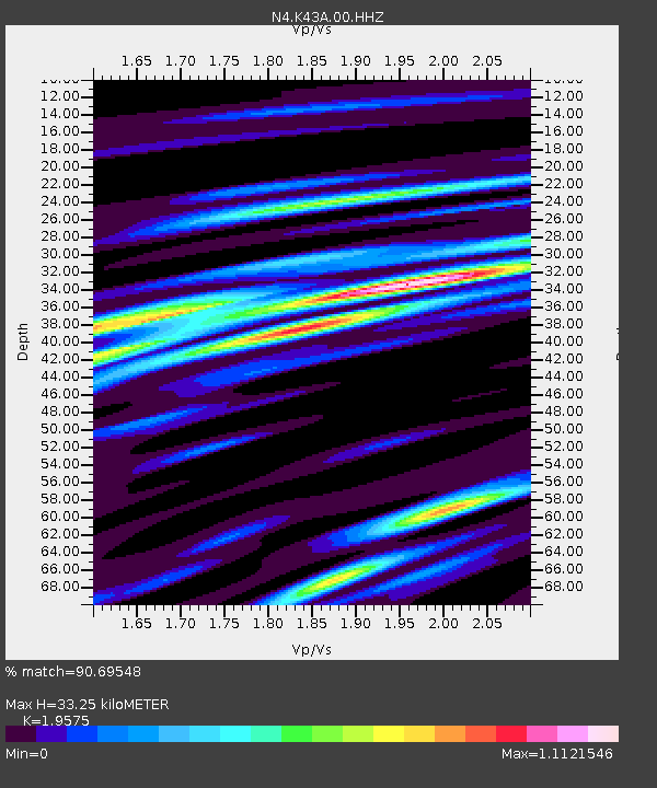
| Estimated Moho Depth: |
33.25 km |
| Estimated Crust Vp/Vs: |
1.96 |
| Assumed Crust Vp: |
6.571 km/s |
| Estimated Crust Vs: |
3.357 km/s |
| Estimated Crust Poisson's Ratio: |
0.32 |
|
| Radial Match: |
90.69548 % |
| Radial Bump: |
298 |
| Transverse Match: |
54.631165 % |
| Transverse Bump: |
400 |
| SOD ConfigId: |
25131211 |
| Insert Time: |
2021-07-31 21:16:47.780 +0000 |
| GWidth: |
2.5 |
| Max Bumps: |
400 |
| Tol: |
0.001 |
|

Signal To Noise
| Channel | StoN | STA | LTA |
| N4:K43A:00:HHZ:20210717T21:02:41.970007Z | 20.825876 | 1.6405911E-6 | 7.877657E-8 |
| N4:K43A:00:HH1:20210717T21:02:41.970007Z | 17.91121 | 1.0990531E-6 | 6.1361185E-8 |
| N4:K43A:00:HH2:20210717T21:02:41.970007Z | 4.1626916 | 2.5927866E-7 | 6.2286304E-8 |
| Arrivals |
| Ps | 5.2 SECOND |
| PpPs | 14 SECOND |
| PsPs/PpSs | 19 SECOND |


