You are here: Home > Network List > OH - Ohio Seismic Network Stations List
> Station MWLO Mercer Wildlife Area Ohio > Earthquake Result Viewer
MWLO Mercer Wildlife Area Ohio - Earthquake Result Viewer
| Earthquake location: |
South Of Panama |
| Earthquake latitude/longitude: |
6.8/-82.7 |
| Earthquake time(UTC): |
2021/07/17 (198) 20:56:10 GMT |
| Earthquake Depth: |
4.1 km |
| Earthquake Magnitude: |
6.1 mww |
| Earthquake Catalog/Contributor: |
NEIC PDE/us |
|
| Network: |
OH Ohio Seismic Network |
| Station: |
MWLO Mercer Wildlife Area Ohio |
| Lat/Lon: |
40.50 N/84.57 W |
| Elevation: |
266 m |
|
| Distance: |
33.6 deg |
| Az: |
357.392 deg |
| Baz: |
176.602 deg |
| Ray Param: |
0.07817362 |
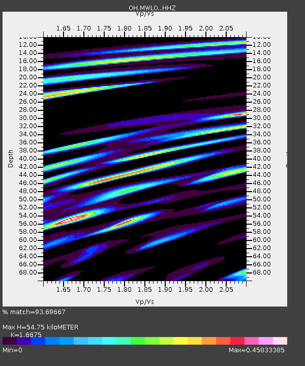
| Estimated Moho Depth: |
54.75 km |
| Estimated Crust Vp/Vs: |
1.67 |
| Assumed Crust Vp: |
6.498 km/s |
| Estimated Crust Vs: |
3.897 km/s |
| Estimated Crust Poisson's Ratio: |
0.22 |
|
| Radial Match: |
93.69667 % |
| Radial Bump: |
391 |
| Transverse Match: |
79.20853 % |
| Transverse Bump: |
400 |
| SOD ConfigId: |
25131211 |
| Insert Time: |
2021-07-31 21:22:20.045 +0000 |
| GWidth: |
2.5 |
| Max Bumps: |
400 |
| Tol: |
0.001 |
|

Signal To Noise
| Channel | StoN | STA | LTA |
| OH:MWLO: :HHZ:20210717T21:02:20.399999Z | 18.825567 | 2.5746813E-6 | 1.3676512E-7 |
| OH:MWLO: :HHN:20210717T21:02:20.399999Z | 9.263331 | 1.6440316E-6 | 1.7747736E-7 |
| OH:MWLO: :HHE:20210717T21:02:20.399999Z | 3.5802655 | 4.684613E-7 | 1.3084541E-7 |
| Arrivals |
| Ps | 6.1 SECOND |
| PpPs | 21 SECOND |
| PsPs/PpSs | 27 SECOND |


