You are here: Home > Network List > TA - USArray Transportable Network (new EarthScope stations) Stations List
> Station A36M Sachs Harbour, NT, CAN > Earthquake Result Viewer
A36M Sachs Harbour, NT, CAN - Earthquake Result Viewer

| Earthquake location: |
South Of Panama |
| Earthquake latitude/longitude: |
6.8/-82.7 |
| Earthquake time(UTC): |
2021/07/17 (198) 20:56:10 GMT |
| Earthquake Depth: |
4.1 km |
| Earthquake Magnitude: |
6.1 mww |
| Earthquake Catalog/Contributor: |
NEIC PDE/us |
|
| Network: |
TA USArray Transportable Network (new EarthScope stations) |
| Station: |
A36M Sachs Harbour, NT, CAN |
| Lat/Lon: |
71.99 N/125.25 W |
| Elevation: |
32 m |
|
| Distance: |
70.1 deg |
| Az: |
347.069 deg |
| Baz: |
134.419 deg |
| Ray Param: |
0.05520868 |
| Estimated Moho Depth: |
36.25 km |
| Estimated Crust Vp/Vs: |
1.85 |
| Assumed Crust Vp: |
6.24 km/s |
| Estimated Crust Vs: |
3.368 km/s |
| Estimated Crust Poisson's Ratio: |
0.29 |
|
| Radial Match: |
92.38026 % |
| Radial Bump: |
400 |
| Transverse Match: |
89.562225 % |
| Transverse Bump: |
400 |
| SOD ConfigId: |
25131211 |
| Insert Time: |
2021-07-31 21:25:44.347 +0000 |
| GWidth: |
2.5 |
| Max Bumps: |
400 |
| Tol: |
0.001 |
|
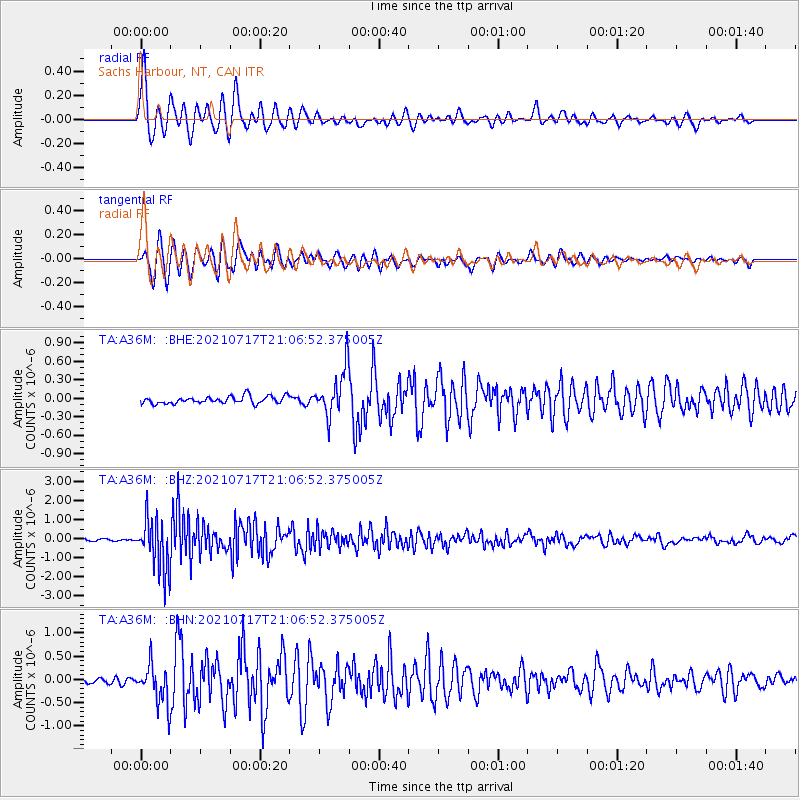
Signal To Noise
| Channel | StoN | STA | LTA |
| TA:A36M: :BHZ:20210717T21:06:52.375005Z | 27.36481 | 1.3738795E-6 | 5.020607E-8 |
| TA:A36M: :BHN:20210717T21:06:52.375005Z | 9.263899 | 4.188955E-7 | 4.521806E-8 |
| TA:A36M: :BHE:20210717T21:06:52.375005Z | 6.3565273 | 3.8013152E-7 | 5.980176E-8 |
| Arrivals |
| Ps | 5.1 SECOND |
| PpPs | 16 SECOND |
| PsPs/PpSs | 21 SECOND |


