You are here: Home > Network List > GS - US Geological Survey Networks Stations List
> Station KAN01 Ward Farm, Argonia, KS, USA > Earthquake Result Viewer
KAN01 Ward Farm, Argonia, KS, USA - Earthquake Result Viewer
| Earthquake location: |
Northern Chile |
| Earthquake latitude/longitude: |
-18.9/-69.6 |
| Earthquake time(UTC): |
2018/01/21 (021) 01:06:42 GMT |
| Earthquake Depth: |
111 km |
| Earthquake Magnitude: |
6.3 Mww |
| Earthquake Catalog/Contributor: |
NEIC PDE/us |
|
| Network: |
GS US Geological Survey Networks |
| Station: |
KAN01 Ward Farm, Argonia, KS, USA |
| Lat/Lon: |
37.15 N/97.76 W |
| Elevation: |
360 m |
|
| Distance: |
61.7 deg |
| Az: |
334.668 deg |
| Baz: |
149.534 deg |
| Ray Param: |
0.060372617 |
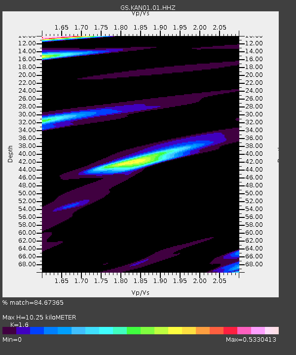
| Estimated Moho Depth: |
10.25 km |
| Estimated Crust Vp/Vs: |
1.60 |
| Assumed Crust Vp: |
6.483 km/s |
| Estimated Crust Vs: |
4.052 km/s |
| Estimated Crust Poisson's Ratio: |
0.18 |
|
| Radial Match: |
84.67365 % |
| Radial Bump: |
400 |
| Transverse Match: |
54.482967 % |
| Transverse Bump: |
400 |
| SOD ConfigId: |
2546091 |
| Insert Time: |
2018-02-04 01:08:35.315 +0000 |
| GWidth: |
2.5 |
| Max Bumps: |
400 |
| Tol: |
0.001 |
|

Signal To Noise
| Channel | StoN | STA | LTA |
| GS:KAN01:01:HHZ:20180121T01:16:18.150012Z | 16.546549 | 3.605286E-6 | 2.178875E-7 |
| GS:KAN01:01:HHN:20180121T01:16:18.150012Z | 6.8686323 | 1.431211E-6 | 2.0836914E-7 |
| GS:KAN01:01:HHE:20180121T01:16:18.150012Z | 3.880297 | 1.2135637E-6 | 3.1275022E-7 |
| Arrivals |
| Ps | 1.0 SECOND |
| PpPs | 3.9 SECOND |
| PsPs/PpSs | 4.9 SECOND |


