You are here: Home > Network List > US - United States National Seismic Network Stations List
> Station BW06 Boulder Array Site 6 (Pinedale), Wyoming, USA > Earthquake Result Viewer
BW06 Boulder Array Site 6 (Pinedale), Wyoming, USA - Earthquake Result Viewer
| Earthquake location: |
South Of Panama |
| Earthquake latitude/longitude: |
6.8/-82.7 |
| Earthquake time(UTC): |
2021/07/17 (198) 20:56:10 GMT |
| Earthquake Depth: |
4.1 km |
| Earthquake Magnitude: |
6.1 mww |
| Earthquake Catalog/Contributor: |
NEIC PDE/us |
|
| Network: |
US United States National Seismic Network |
| Station: |
BW06 Boulder Array Site 6 (Pinedale), Wyoming, USA |
| Lat/Lon: |
42.77 N/109.56 W |
| Elevation: |
2224 m |
|
| Distance: |
42.9 deg |
| Az: |
330.74 deg |
| Baz: |
138.768 deg |
| Ray Param: |
0.07289036 |
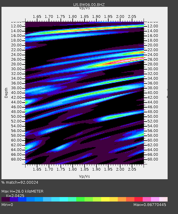
| Estimated Moho Depth: |
26.0 km |
| Estimated Crust Vp/Vs: |
2.04 |
| Assumed Crust Vp: |
6.161 km/s |
| Estimated Crust Vs: |
3.016 km/s |
| Estimated Crust Poisson's Ratio: |
0.34 |
|
| Radial Match: |
92.00024 % |
| Radial Bump: |
387 |
| Transverse Match: |
81.00697 % |
| Transverse Bump: |
400 |
| SOD ConfigId: |
25131211 |
| Insert Time: |
2021-07-31 21:28:43.698 +0000 |
| GWidth: |
2.5 |
| Max Bumps: |
400 |
| Tol: |
0.001 |
|

Signal To Noise
| Channel | StoN | STA | LTA |
| US:BW06:00:BHZ:20210717T21:03:39.049993Z | 60.319443 | 2.0862446E-6 | 3.4586606E-8 |
| US:BW06:00:BH1:20210717T21:03:39.049993Z | 29.105766 | 6.838226E-7 | 2.3494401E-8 |
| US:BW06:00:BH2:20210717T21:03:39.049993Z | 34.81873 | 1.1236439E-6 | 3.227125E-8 |
| Arrivals |
| Ps | 4.6 SECOND |
| PpPs | 12 SECOND |
| PsPs/PpSs | 17 SECOND |


