You are here: Home > Network List > US - United States National Seismic Network Stations List
> Station LONY Lake Ozonia, New York, USA > Earthquake Result Viewer
LONY Lake Ozonia, New York, USA - Earthquake Result Viewer
| Earthquake location: |
South Of Panama |
| Earthquake latitude/longitude: |
6.8/-82.7 |
| Earthquake time(UTC): |
2021/07/17 (198) 20:56:10 GMT |
| Earthquake Depth: |
4.1 km |
| Earthquake Magnitude: |
6.1 mww |
| Earthquake Catalog/Contributor: |
NEIC PDE/us |
|
| Network: |
US United States National Seismic Network |
| Station: |
LONY Lake Ozonia, New York, USA |
| Lat/Lon: |
44.62 N/74.58 W |
| Elevation: |
440 m |
|
| Distance: |
38.3 deg |
| Az: |
9.336 deg |
| Baz: |
193.037 deg |
| Ray Param: |
0.07567635 |
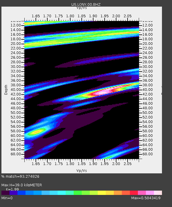
| Estimated Moho Depth: |
39.0 km |
| Estimated Crust Vp/Vs: |
1.99 |
| Assumed Crust Vp: |
6.419 km/s |
| Estimated Crust Vs: |
3.226 km/s |
| Estimated Crust Poisson's Ratio: |
0.33 |
|
| Radial Match: |
93.274826 % |
| Radial Bump: |
282 |
| Transverse Match: |
82.69807 % |
| Transverse Bump: |
387 |
| SOD ConfigId: |
25131211 |
| Insert Time: |
2021-07-31 21:29:12.043 +0000 |
| GWidth: |
2.5 |
| Max Bumps: |
400 |
| Tol: |
0.001 |
|

Signal To Noise
| Channel | StoN | STA | LTA |
| US:LONY:00:BHZ:20210717T21:03:00.849004Z | 17.085373 | 1.3369022E-6 | 7.824834E-8 |
| US:LONY:00:BH1:20210717T21:03:00.849004Z | 10.298396 | 6.550266E-7 | 6.3604716E-8 |
| US:LONY:00:BH2:20210717T21:03:00.849004Z | 1.6700081 | 8.035466E-8 | 4.811633E-8 |
| Arrivals |
| Ps | 6.4 SECOND |
| PpPs | 17 SECOND |
| PsPs/PpSs | 23 SECOND |


