You are here: Home > Network List > UW - Pacific Northwest Regional Seismic Network Stations List
> Station GNW Green Mountain (BB) > Earthquake Result Viewer
GNW Green Mountain (BB) - Earthquake Result Viewer
| Earthquake location: |
South Of Panama |
| Earthquake latitude/longitude: |
6.8/-82.7 |
| Earthquake time(UTC): |
2021/07/17 (198) 20:56:10 GMT |
| Earthquake Depth: |
4.1 km |
| Earthquake Magnitude: |
6.1 mww |
| Earthquake Catalog/Contributor: |
NEIC PDE/us |
|
| Network: |
UW Pacific Northwest Regional Seismic Network |
| Station: |
GNW Green Mountain (BB) |
| Lat/Lon: |
47.56 N/122.83 W |
| Elevation: |
160 m |
|
| Distance: |
53.1 deg |
| Az: |
326.888 deg |
| Baz: |
126.774 deg |
| Ray Param: |
0.06637666 |
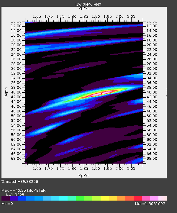
| Estimated Moho Depth: |
40.25 km |
| Estimated Crust Vp/Vs: |
1.92 |
| Assumed Crust Vp: |
6.566 km/s |
| Estimated Crust Vs: |
3.415 km/s |
| Estimated Crust Poisson's Ratio: |
0.31 |
|
| Radial Match: |
89.38256 % |
| Radial Bump: |
400 |
| Transverse Match: |
78.28065 % |
| Transverse Bump: |
400 |
| SOD ConfigId: |
25131211 |
| Insert Time: |
2021-07-31 21:31:01.602 +0000 |
| GWidth: |
2.5 |
| Max Bumps: |
400 |
| Tol: |
0.001 |
|

Signal To Noise
| Channel | StoN | STA | LTA |
| UW:GNW: :HHZ:20210717T21:04:57.320013Z | 15.257767 | 1.0440157E-6 | 6.8425194E-8 |
| UW:GNW: :HHN:20210717T21:04:57.320013Z | 5.23948 | 4.5799808E-7 | 8.7412886E-8 |
| UW:GNW: :HHE:20210717T21:04:57.320013Z | 3.7776473 | 4.3518853E-7 | 1.1520094E-7 |
| Arrivals |
| Ps | 6.0 SECOND |
| PpPs | 17 SECOND |
| PsPs/PpSs | 23 SECOND |


