You are here: Home > Network List > KZ - Kazakhstan Network Stations List
> Station ZRN Zerenda, Kazakstan > Earthquake Result Viewer
ZRN Zerenda, Kazakstan - Earthquake Result Viewer
| Earthquake location: |
Halmahera, Indonesia |
| Earthquake latitude/longitude: |
-1.4/127.5 |
| Earthquake time(UTC): |
1995/02/13 (044) 15:04:26 GMT |
| Earthquake Depth: |
33 km |
| Earthquake Magnitude: |
6.2 MB, 6.8 MS, 6.8 UNKNOWN, 6.7 MW |
| Earthquake Catalog/Contributor: |
WHDF/NEIC |
|
| Network: |
KZ Kazakhstan Network |
| Station: |
ZRN Zerenda, Kazakstan |
| Lat/Lon: |
52.95 N/69.00 E |
| Elevation: |
380 m |
|
| Distance: |
72.7 deg |
| Az: |
327.287 deg |
| Baz: |
116.756 deg |
| Ray Param: |
0.053435802 |
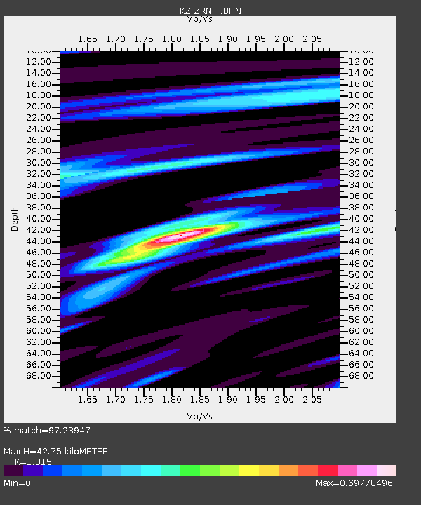
| Estimated Moho Depth: |
42.75 km |
| Estimated Crust Vp/Vs: |
1.82 |
| Assumed Crust Vp: |
6.498 km/s |
| Estimated Crust Vs: |
3.58 km/s |
| Estimated Crust Poisson's Ratio: |
0.28 |
|
| Radial Match: |
97.23947 % |
| Radial Bump: |
272 |
| Transverse Match: |
90.58543 % |
| Transverse Bump: |
400 |
| SOD ConfigId: |
6273 |
| Insert Time: |
2010-03-09 10:34:13.894 +0000 |
| GWidth: |
2.5 |
| Max Bumps: |
400 |
| Tol: |
0.001 |
|

Signal To Noise
| Channel | StoN | STA | LTA |
| KZ:ZRN: :BHN:19950213T15:15:20.297021Z | 3.2481315 | 3.5629903E-6 | 1.0969353E-6 |
| KZ:ZRN: :BHE:19950213T15:15:20.297021Z | 7.086295 | 5.223704E-6 | 7.3715586E-7 |
| KZ:ZRN: :BHZ:19950213T15:15:20.297021Z | 8.897183 | 1.460594E-5 | 1.6416365E-6 |
| Arrivals |
| Ps | 5.6 SECOND |
| PpPs | 18 SECOND |
| PsPs/PpSs | 23 SECOND |


