You are here: Home > Network List > AG - Arkansas Seismic Network Stations List
> Station U40A Yellville, AR > Earthquake Result Viewer
U40A Yellville, AR - Earthquake Result Viewer
| Earthquake location: |
Northern Mid-Atlantic Ridge |
| Earthquake latitude/longitude: |
28.4/-43.7 |
| Earthquake time(UTC): |
2021/07/17 (198) 21:31:18 GMT |
| Earthquake Depth: |
10 km |
| Earthquake Magnitude: |
5.5 Mww |
| Earthquake Catalog/Contributor: |
NEIC PDE/us |
|
| Network: |
AG Arkansas Seismic Network |
| Station: |
U40A Yellville, AR |
| Lat/Lon: |
36.36 N/92.85 W |
| Elevation: |
374 m |
|
| Distance: |
41.9 deg |
| Az: |
293.826 deg |
| Baz: |
86.343 deg |
| Ray Param: |
0.073508084 |
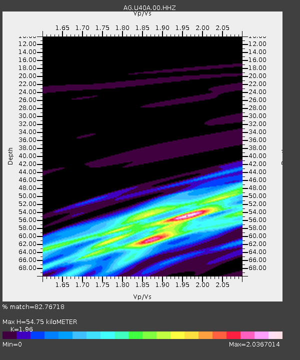
| Estimated Moho Depth: |
54.75 km |
| Estimated Crust Vp/Vs: |
1.96 |
| Assumed Crust Vp: |
6.53 km/s |
| Estimated Crust Vs: |
3.332 km/s |
| Estimated Crust Poisson's Ratio: |
0.32 |
|
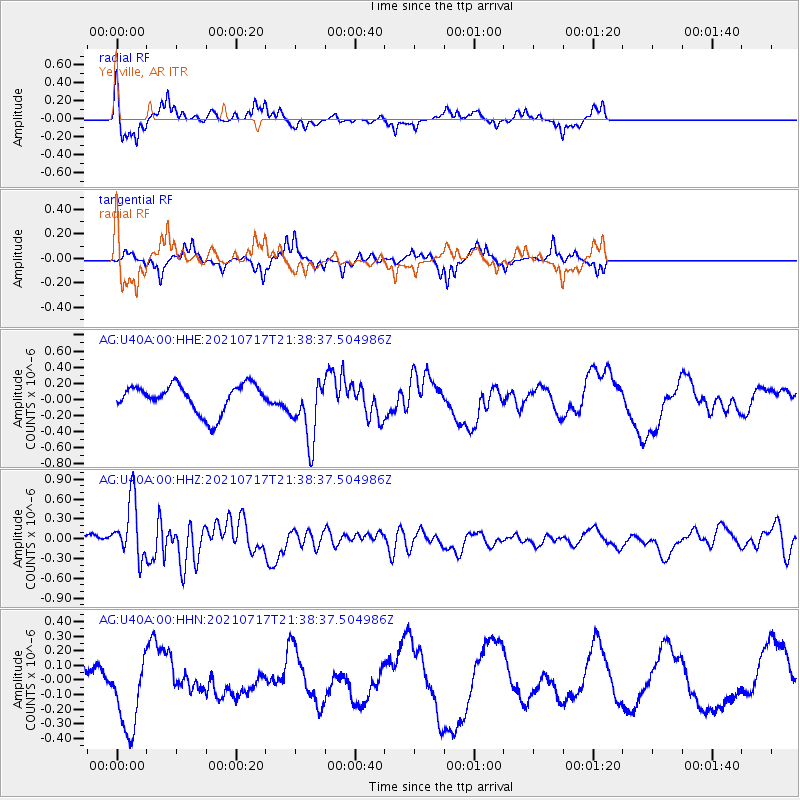
| Radial Match: |
82.76718 % |
| Radial Bump: |
355 |
| Transverse Match: |
66.53195 % |
| Transverse Bump: |
274 |
| SOD ConfigId: |
25131211 |
| Insert Time: |
2021-07-31 21:34:28.602 +0000 |
| GWidth: |
2.5 |
| Max Bumps: |
400 |
| Tol: |
0.001 |
|
Signal To Noise
| Channel | StoN | STA | LTA |
| AG:U40A:00:HHZ:20210717T21:38:37.504986Z | 2.0350413 | 4.4364364E-7 | 2.1800228E-7 |
| AG:U40A:00:HHN:20210717T21:38:37.504986Z | 1.357919 | 2.550487E-7 | 1.878232E-7 |
| AG:U40A:00:HHE:20210717T21:38:37.504986Z | 2.2455893 | 3.882746E-7 | 1.7290543E-7 |
| Arrivals |
| Ps | 8.6 SECOND |
| PpPs | 23 SECOND |
| PsPs/PpSs | 32 SECOND |


