You are here: Home > Network List > KZ - Kazakhstan Network Stations List
> Station ZRN Zerenda, Kazakstan > Earthquake Result Viewer
ZRN Zerenda, Kazakstan - Earthquake Result Viewer
| Earthquake location: |
Timor Region |
| Earthquake latitude/longitude: |
-8.4/125.1 |
| Earthquake time(UTC): |
1995/05/14 (134) 11:33:21 GMT |
| Earthquake Depth: |
33 km |
| Earthquake Magnitude: |
6.1 MB, 6.9 MS, 7.1 UNKNOWN, 6.9 MW |
| Earthquake Catalog/Contributor: |
WHDF/NEIC |
|
| Network: |
KZ Kazakhstan Network |
| Station: |
ZRN Zerenda, Kazakstan |
| Lat/Lon: |
52.95 N/69.00 E |
| Elevation: |
380 m |
|
| Distance: |
77.4 deg |
| Az: |
329.033 deg |
| Baz: |
122.714 deg |
| Ray Param: |
0.050320346 |
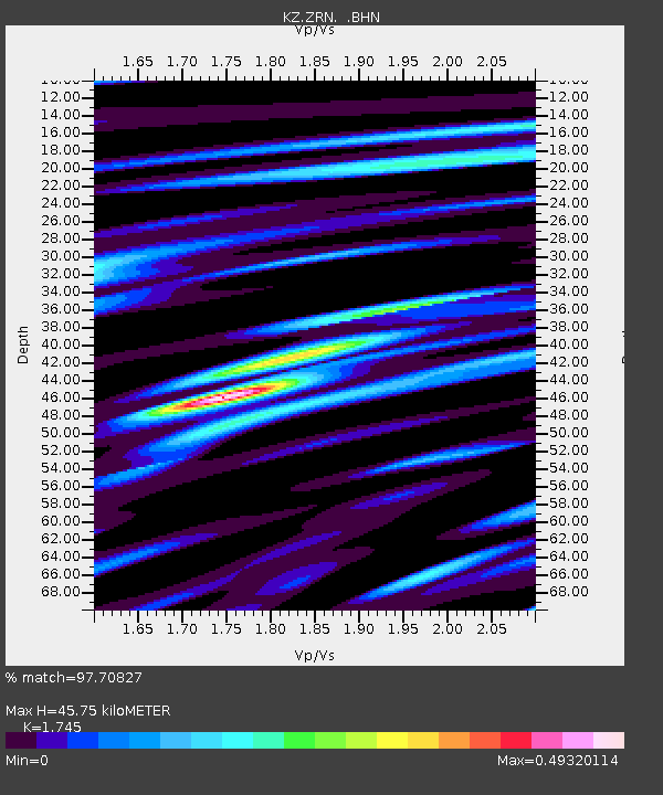
| Estimated Moho Depth: |
45.75 km |
| Estimated Crust Vp/Vs: |
1.75 |
| Assumed Crust Vp: |
6.498 km/s |
| Estimated Crust Vs: |
3.724 km/s |
| Estimated Crust Poisson's Ratio: |
0.26 |
|
| Radial Match: |
97.70827 % |
| Radial Bump: |
323 |
| Transverse Match: |
88.32454 % |
| Transverse Bump: |
400 |
| SOD ConfigId: |
6273 |
| Insert Time: |
2010-03-09 10:34:41.620 +0000 |
| GWidth: |
2.5 |
| Max Bumps: |
400 |
| Tol: |
0.001 |
|

Signal To Noise
| Channel | StoN | STA | LTA |
| KZ:ZRN: :BHN:19950514T11:44:42.331006Z | 11.352679 | 1.9547354E-6 | 1.7218274E-7 |
| KZ:ZRN: :BHE:19950514T11:44:42.331006Z | 5.995295 | 2.0925793E-6 | 3.4903695E-7 |
| KZ:ZRN: :BHZ:19950514T11:44:42.331006Z | 12.570054 | 7.158636E-6 | 5.6949926E-7 |
| Arrivals |
| Ps | 5.4 SECOND |
| PpPs | 19 SECOND |
| PsPs/PpSs | 24 SECOND |


