You are here: Home > Network List > CI - Caltech Regional Seismic Network Stations List
> Station SWS Sam W. Stewart, Westmorland, CA, USA > Earthquake Result Viewer
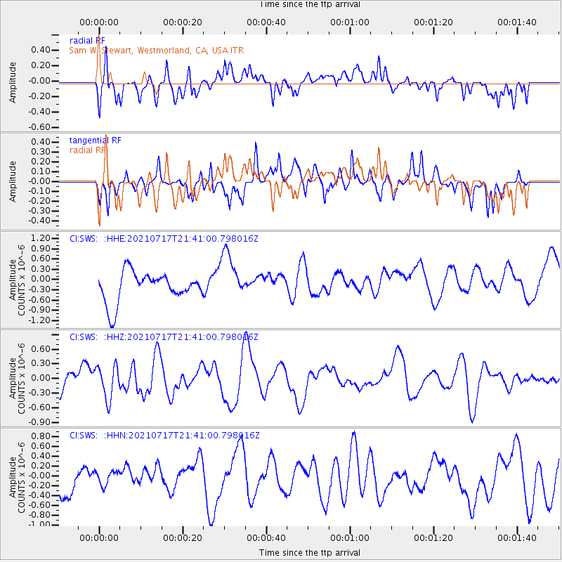
SWS Sam W. Stewart, Westmorland, CA, USA - Earthquake Result Viewer
*The percent match for this event was below the threshold and hence no stack was calculated.
| Earthquake location: |
Northern Mid-Atlantic Ridge |
| Earthquake latitude/longitude: |
28.4/-43.7 |
| Earthquake time(UTC): |
2021/07/17 (198) 21:31:18 GMT |
| Earthquake Depth: |
10 km |
| Earthquake Magnitude: |
5.5 Mww |
| Earthquake Catalog/Contributor: |
NEIC PDE/us |
|
| Network: |
CI Caltech Regional Seismic Network |
| Station: |
SWS Sam W. Stewart, Westmorland, CA, USA |
| Lat/Lon: |
32.94 N/115.80 W |
| Elevation: |
140 m |
|
| Distance: |
61.1 deg |
| Az: |
293.877 deg |
| Baz: |
73.266 deg |
| Ray Param: |
$rayparam |
*The percent match for this event was below the threshold and hence was not used in the summary stack. |
|
| Radial Match: |
51.89214 % |
| Radial Bump: |
400 |
| Transverse Match: |
50.736828 % |
| Transverse Bump: |
400 |
| SOD ConfigId: |
25131211 |
| Insert Time: |
2021-07-31 21:40:51.082 +0000 |
| GWidth: |
2.5 |
| Max Bumps: |
400 |
| Tol: |
0.001 |
|
Signal To Noise
| Channel | StoN | STA | LTA |
| CI:SWS: :HHZ:20210717T21:41:00.798016Z | 1.7352679 | 3.465028E-7 | 1.9968259E-7 |
| CI:SWS: :HHN:20210717T21:41:00.798016Z | 0.5036201 | 1.4169024E-7 | 2.813435E-7 |
| CI:SWS: :HHE:20210717T21:41:00.798016Z | 1.692328 | 7.37475E-7 | 4.3577543E-7 |
| Arrivals |
| Ps | |
| PpPs | |
| PsPs/PpSs | |


