You are here: Home > Network List > KZ - Kazakhstan Network Stations List
> Station ZRN Zerenda, Kazakstan > Earthquake Result Viewer
ZRN Zerenda, Kazakstan - Earthquake Result Viewer
| Earthquake location: |
Ryukyu Islands, Japan |
| Earthquake latitude/longitude: |
27.9/130.3 |
| Earthquake time(UTC): |
1995/10/18 (291) 10:37:26 GMT |
| Earthquake Depth: |
27 km |
| Earthquake Magnitude: |
6.5 MB, 6.8 MS, 6.7 UNKNOWN, 7.1 MW |
| Earthquake Catalog/Contributor: |
WHDF/NEIC |
|
| Network: |
KZ Kazakhstan Network |
| Station: |
ZRN Zerenda, Kazakstan |
| Lat/Lon: |
52.95 N/69.00 E |
| Elevation: |
380 m |
|
| Distance: |
51.1 deg |
| Az: |
317.0 deg |
| Baz: |
94.136 deg |
| Ray Param: |
0.067570046 |
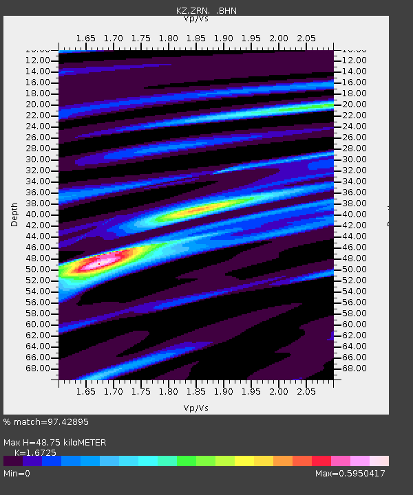
| Estimated Moho Depth: |
48.75 km |
| Estimated Crust Vp/Vs: |
1.67 |
| Assumed Crust Vp: |
6.498 km/s |
| Estimated Crust Vs: |
3.885 km/s |
| Estimated Crust Poisson's Ratio: |
0.22 |
|
| Radial Match: |
97.42895 % |
| Radial Bump: |
280 |
| Transverse Match: |
85.6039 % |
| Transverse Bump: |
400 |
| SOD ConfigId: |
6273 |
| Insert Time: |
2010-03-09 10:35:17.031 +0000 |
| GWidth: |
2.5 |
| Max Bumps: |
400 |
| Tol: |
0.001 |
|

Signal To Noise
| Channel | StoN | STA | LTA |
| KZ:ZRN: :BHN:19951018T10:45:55.827008Z | 1.3331184 | 5.2954707E-8 | 3.9722433E-8 |
| KZ:ZRN: :BHE:19951018T10:45:55.827008Z | 5.731396 | 3.4435612E-7 | 6.0082414E-8 |
| KZ:ZRN: :BHZ:19951018T10:45:55.827008Z | 7.982697 | 6.3687344E-7 | 7.9781735E-8 |
| Arrivals |
| Ps | 5.4 SECOND |
| PpPs | 19 SECOND |
| PsPs/PpSs | 24 SECOND |


