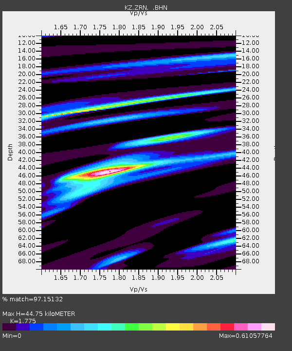
ZRN Zerenda, Kazakstan - Earthquake Result Viewer

Earthquake location: South Of Sumbawa, Indonesia
Earthquake latitude/longitude: -11.2/118.7
Earthquake time(UTC): 1996/02/12 (043) 09:08:10 GMT
Earthquake Depth: 33 km
Earthquake Magnitude: 5.8 MB, 5.8 MS, 6.1 UNKNOWN, 6.0 MW
Earthquake Catalog/Contributor: WHDF/NEIC
Network: KZ Kazakhstan Network
Station: ZRN Zerenda, Kazakstan
Lat/Lon: 52.95 N/69.00 E
Elevation: 380 m
Distance: 76.6 deg
Az: 331.704 deg
Baz: 129.754 deg
Ray Param: 0.050821725
Estimated Moho Depth: 44.75 km
Estimated Crust Vp/Vs: 1.77
Assumed Crust Vp: 6.498 km/s
Estimated Crust Vs: 3.661 km/s
Estimated Crust Poisson's Ratio: 0.27
Radial Match: 97.15132 %
Radial Bump: 278
Transverse Match: 85.63513 %
Transverse Bump: 400
SOD ConfigId: 6273
Insert Time: 2010-03-09 10:36:12.513 +0000
GWidth: 2.5
Max Bumps: 400
Tol: 0.001

Signal To Noise

ChannelStoNSTALTA
KZ:ZRN: :BHN:19960212T09:19:26.933008Z1.42973142.3679334E-81.6562087E-8
KZ:ZRN: :BHE:19960212T09:19:26.933008Z1.5364632.3052648E-81.500371E-8
KZ:ZRN: :BHZ:19960212T09:19:26.933008Z3.5864276.928016E-81.9317321E-8
Arrivals
Ps5.5 SECOND
PpPs19 SECOND
PsPs/PpSs24 SECOND