You are here: Home > Network List > KZ - Kazakhstan Network Stations List
> Station ZRN Zerenda, Kazakstan > Earthquake Result Viewer
ZRN Zerenda, Kazakstan - Earthquake Result Viewer
| Earthquake location: |
Northern Molucca Sea |
| Earthquake latitude/longitude: |
1.7/126.1 |
| Earthquake time(UTC): |
1996/02/28 (059) 09:44:09 GMT |
| Earthquake Depth: |
103 km |
| Earthquake Magnitude: |
6.1 MB, 6.4 UNKNOWN, 6.4 MW |
| Earthquake Catalog/Contributor: |
WHDF/NEIC |
|
| Network: |
KZ Kazakhstan Network |
| Station: |
ZRN Zerenda, Kazakstan |
| Lat/Lon: |
52.95 N/69.00 E |
| Elevation: |
380 m |
|
| Distance: |
69.4 deg |
| Az: |
327.123 deg |
| Baz: |
116.267 deg |
| Ray Param: |
0.05543376 |
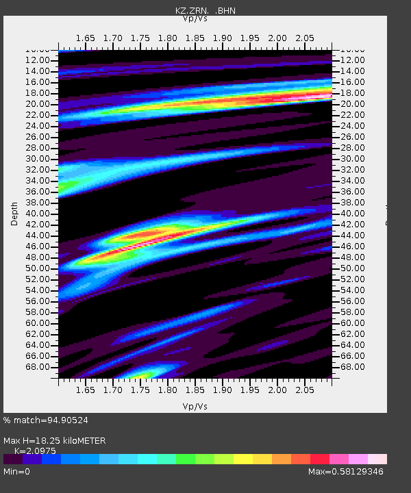
| Estimated Moho Depth: |
18.25 km |
| Estimated Crust Vp/Vs: |
2.10 |
| Assumed Crust Vp: |
6.498 km/s |
| Estimated Crust Vs: |
3.098 km/s |
| Estimated Crust Poisson's Ratio: |
0.35 |
|
| Radial Match: |
94.90524 % |
| Radial Bump: |
237 |
| Transverse Match: |
83.2694 % |
| Transverse Bump: |
397 |
| SOD ConfigId: |
6273 |
| Insert Time: |
2010-03-09 10:36:22.031 +0000 |
| GWidth: |
2.5 |
| Max Bumps: |
400 |
| Tol: |
0.001 |
|

Signal To Noise
| Channel | StoN | STA | LTA |
| KZ:ZRN: :BHN:19960228T09:54:35.157019Z | 3.1450481 | 1.4522655E-7 | 4.6176257E-8 |
| KZ:ZRN: :BHE:19960228T09:54:35.157019Z | 6.1174912 | 1.7300938E-7 | 2.8281102E-8 |
| KZ:ZRN: :BHZ:19960228T09:54:35.157019Z | 6.9389935 | 4.6920687E-7 | 6.761886E-8 |
| Arrivals |
| Ps | 3.2 SECOND |
| PpPs | 8.4 SECOND |
| PsPs/PpSs | 12 SECOND |


