You are here: Home > Network List > KZ - Kazakhstan Network Stations List
> Station ZRN Zerenda, Kazakstan > Earthquake Result Viewer
ZRN Zerenda, Kazakstan - Earthquake Result Viewer
| Earthquake location: |
Solomon Islands |
| Earthquake latitude/longitude: |
-6.5/155.0 |
| Earthquake time(UTC): |
1996/04/29 (120) 14:40:41 GMT |
| Earthquake Depth: |
44 km |
| Earthquake Magnitude: |
6.3 MB, 7.5 MS, 7.2 UNKNOWN, 6.8 ME |
| Earthquake Catalog/Contributor: |
WHDF/NEIC |
|
| Network: |
KZ Kazakhstan Network |
| Station: |
ZRN Zerenda, Kazakstan |
| Lat/Lon: |
52.95 N/69.00 E |
| Elevation: |
380 m |
|
| Distance: |
92.7 deg |
| Az: |
322.822 deg |
| Baz: |
97.102 deg |
| Ray Param: |
0.041381303 |
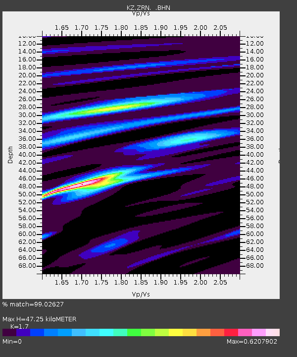
| Estimated Moho Depth: |
47.25 km |
| Estimated Crust Vp/Vs: |
1.70 |
| Assumed Crust Vp: |
6.498 km/s |
| Estimated Crust Vs: |
3.822 km/s |
| Estimated Crust Poisson's Ratio: |
0.24 |
|
| Radial Match: |
99.02627 % |
| Radial Bump: |
321 |
| Transverse Match: |
90.420654 % |
| Transverse Bump: |
400 |
| SOD ConfigId: |
6273 |
| Insert Time: |
2010-03-09 10:36:33.189 +0000 |
| GWidth: |
2.5 |
| Max Bumps: |
400 |
| Tol: |
0.001 |
|

Signal To Noise
| Channel | StoN | STA | LTA |
| KZ:ZRN: :BHN:19960429T14:53:17.229004Z | 7.403984 | 4.782455E-8 | 6.4592993E-9 |
| KZ:ZRN: :BHE:19960429T14:53:17.229004Z | 20.40457 | 1.8210515E-7 | 8.924725E-9 |
| KZ:ZRN: :BHZ:19960429T14:53:17.229004Z | 40.43777 | 5.422419E-7 | 1.34092915E-8 |
| Arrivals |
| Ps | 5.2 SECOND |
| PpPs | 19 SECOND |
| PsPs/PpSs | 24 SECOND |


