You are here: Home > Network List > AV - Alaska Volcano Observatory Stations List
> Station MAPS Pakushin Southeast, Makushin Volcano, Alaska > Earthquake Result Viewer
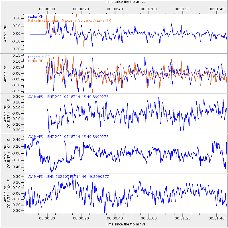
MAPS Pakushin Southeast, Makushin Volcano, Alaska - Earthquake Result Viewer
*The percent match for this event was below the threshold and hence no stack was calculated.
| Earthquake location: |
Southern Iran |
| Earthquake latitude/longitude: |
29.7/51.1 |
| Earthquake time(UTC): |
2021/07/18 (199) 14:34:19 GMT |
| Earthquake Depth: |
10 km |
| Earthquake Magnitude: |
5.4 Mww |
| Earthquake Catalog/Contributor: |
NEIC PDE/us |
|
| Network: |
AV Alaska Volcano Observatory |
| Station: |
MAPS Pakushin Southeast, Makushin Volcano, Alaska |
| Lat/Lon: |
53.81 N/166.94 W |
| Elevation: |
333 m |
|
| Distance: |
90.5 deg |
| Az: |
21.452 deg |
| Baz: |
327.554 deg |
| Ray Param: |
$rayparam |
*The percent match for this event was below the threshold and hence was not used in the summary stack. |
|
| Radial Match: |
73.65064 % |
| Radial Bump: |
400 |
| Transverse Match: |
58.71835 % |
| Transverse Bump: |
400 |
| SOD ConfigId: |
25131211 |
| Insert Time: |
2021-08-01 14:39:52.615 +0000 |
| GWidth: |
2.5 |
| Max Bumps: |
400 |
| Tol: |
0.001 |
|
Signal To Noise
| Channel | StoN | STA | LTA |
| AV:MAPS: :BHZ:20210718T14:46:49.899027Z | 2.7698236 | 4.6120357E-7 | 1.6651009E-7 |
| AV:MAPS: :BHN:20210718T14:46:49.899027Z | 0.8943337 | 9.0786386E-8 | 1.01512875E-7 |
| AV:MAPS: :BHE:20210718T14:46:49.899027Z | 1.1759365 | 1.35824E-7 | 1.15502836E-7 |
| Arrivals |
| Ps | |
| PpPs | |
| PsPs/PpSs | |


