You are here: Home > Network List > TA - USArray Transportable Network (new EarthScope stations) Stations List
> Station TUL3 Leonard, OK, USA > Earthquake Result Viewer
TUL3 Leonard, OK, USA - Earthquake Result Viewer
| Earthquake location: |
Northern Chile |
| Earthquake latitude/longitude: |
-18.9/-69.6 |
| Earthquake time(UTC): |
2018/01/21 (021) 01:06:42 GMT |
| Earthquake Depth: |
111 km |
| Earthquake Magnitude: |
6.3 Mww |
| Earthquake Catalog/Contributor: |
NEIC PDE/us |
|
| Network: |
TA USArray Transportable Network (new EarthScope stations) |
| Station: |
TUL3 Leonard, OK, USA |
| Lat/Lon: |
35.91 N/95.79 W |
| Elevation: |
265 m |
|
| Distance: |
59.9 deg |
| Az: |
335.542 deg |
| Baz: |
151.126 deg |
| Ray Param: |
0.061579164 |
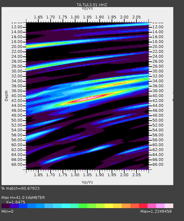
| Estimated Moho Depth: |
41.0 km |
| Estimated Crust Vp/Vs: |
1.85 |
| Assumed Crust Vp: |
6.498 km/s |
| Estimated Crust Vs: |
3.517 km/s |
| Estimated Crust Poisson's Ratio: |
0.29 |
|
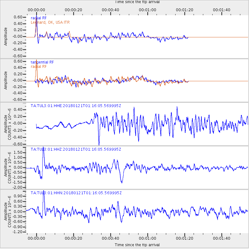
| Radial Match: |
80.67923 % |
| Radial Bump: |
400 |
| Transverse Match: |
47.4578 % |
| Transverse Bump: |
400 |
| SOD ConfigId: |
2546091 |
| Insert Time: |
2018-02-04 01:11:15.452 +0000 |
| GWidth: |
2.5 |
| Max Bumps: |
400 |
| Tol: |
0.001 |
|
Signal To Noise
| Channel | StoN | STA | LTA |
| TA:TUL3:01:HHZ:20180121T01:16:05.569995Z | 16.681704 | 8.3630397E-7 | 5.013301E-8 |
| TA:TUL3:01:HHN:20180121T01:16:05.569995Z | 4.0387025 | 4.5311793E-7 | 1.1219394E-7 |
| TA:TUL3:01:HHE:20180121T01:16:05.569995Z | 5.160643 | 2.6448393E-7 | 5.125019E-8 |
| Arrivals |
| Ps | 5.6 SECOND |
| PpPs | 17 SECOND |
| PsPs/PpSs | 23 SECOND |


