You are here: Home > Network List > G - GEOSCOPE Stations List
> Station INU Inuyama, Japan > Earthquake Result Viewer
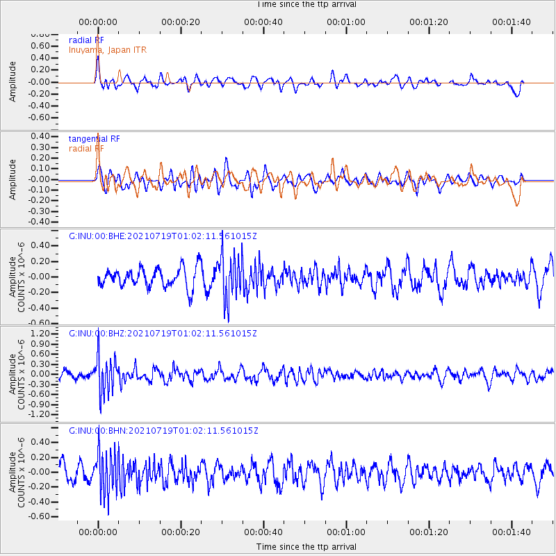
INU Inuyama, Japan - Earthquake Result Viewer
*The percent match for this event was below the threshold and hence no stack was calculated.
| Earthquake location: |
Minahassa Peninsula, Sulawesi |
| Earthquake latitude/longitude: |
-0.0/123.2 |
| Earthquake time(UTC): |
2021/07/19 (200) 00:55:43 GMT |
| Earthquake Depth: |
159 km |
| Earthquake Magnitude: |
5.2 Mww |
| Earthquake Catalog/Contributor: |
NEIC PDE/us |
|
| Network: |
G GEOSCOPE |
| Station: |
INU Inuyama, Japan |
| Lat/Lon: |
35.35 N/137.03 E |
| Elevation: |
132 m |
|
| Distance: |
37.5 deg |
| Az: |
18.696 deg |
| Baz: |
203.086 deg |
| Ray Param: |
$rayparam |
*The percent match for this event was below the threshold and hence was not used in the summary stack. |
|
| Radial Match: |
67.43794 % |
| Radial Bump: |
400 |
| Transverse Match: |
43.33873 % |
| Transverse Bump: |
400 |
| SOD ConfigId: |
25131211 |
| Insert Time: |
2021-08-02 01:01:32.862 +0000 |
| GWidth: |
2.5 |
| Max Bumps: |
400 |
| Tol: |
0.001 |
|
Signal To Noise
| Channel | StoN | STA | LTA |
| G:INU:00:BHZ:20210719T01:02:11.561015Z | 6.400434 | 5.4166924E-7 | 8.463008E-8 |
| G:INU:00:BHN:20210719T01:02:11.561015Z | 2.5688717 | 2.832925E-7 | 1.10278954E-7 |
| G:INU:00:BHE:20210719T01:02:11.561015Z | 2.3154066 | 2.8578714E-7 | 1.2342849E-7 |
| Arrivals |
| Ps | |
| PpPs | |
| PsPs/PpSs | |


