You are here: Home > Network List > GO - National Seismic Network of Georgia Stations List
> Station TBLG Delisi, Georgia > Earthquake Result Viewer
TBLG Delisi, Georgia - Earthquake Result Viewer
*The percent match for this event was below the threshold and hence no stack was calculated.
| Earthquake location: |
Minahassa Peninsula, Sulawesi |
| Earthquake latitude/longitude: |
-0.0/123.2 |
| Earthquake time(UTC): |
2021/07/19 (200) 00:55:43 GMT |
| Earthquake Depth: |
159 km |
| Earthquake Magnitude: |
5.2 Mww |
| Earthquake Catalog/Contributor: |
NEIC PDE/us |
|
| Network: |
GO National Seismic Network of Georgia |
| Station: |
TBLG Delisi, Georgia |
| Lat/Lon: |
41.73 N/44.74 E |
| Elevation: |
510 m |
|
| Distance: |
81.4 deg |
| Az: |
312.119 deg |
| Baz: |
97.696 deg |
| Ray Param: |
$rayparam |
*The percent match for this event was below the threshold and hence was not used in the summary stack. |
|
| Radial Match: |
58.384533 % |
| Radial Bump: |
396 |
| Transverse Match: |
66.69648 % |
| Transverse Bump: |
400 |
| SOD ConfigId: |
25131211 |
| Insert Time: |
2021-08-02 01:01:43.584 +0000 |
| GWidth: |
2.5 |
| Max Bumps: |
400 |
| Tol: |
0.001 |
|
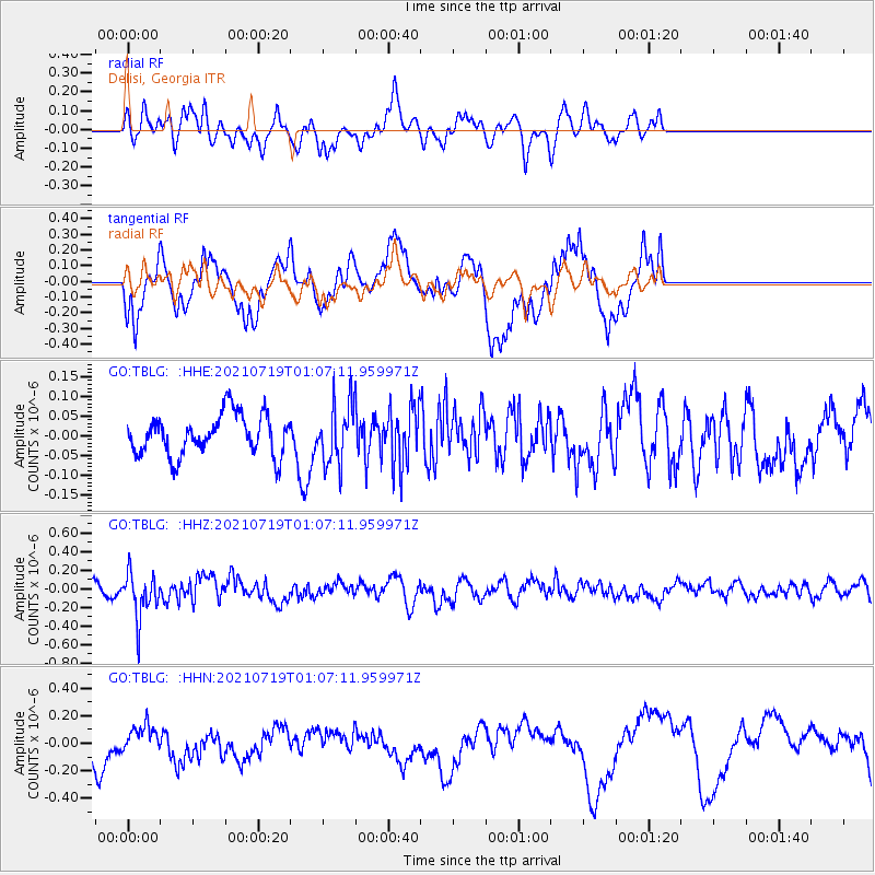
Signal To Noise
| Channel | StoN | STA | LTA |
| GO:TBLG: :HHZ:20210719T01:07:11.959971Z | 3.1273646 | 2.4020218E-7 | 7.680658E-8 |
| GO:TBLG: :HHN:20210719T01:07:11.959971Z | 1.1868752 | 1.02369114E-7 | 8.625094E-8 |
| GO:TBLG: :HHE:20210719T01:07:11.959971Z | 1.4343253 | 7.333259E-8 | 5.1126893E-8 |
| Arrivals |
| Ps | |
| PpPs | |
| PsPs/PpSs | |


