You are here: Home > Network List > TX - Texas Seismological Network Stations List
> Station SN07 Snyder 07 > Earthquake Result Viewer
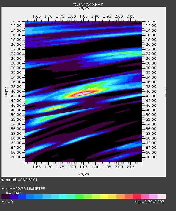
SN07 Snyder 07 - Earthquake Result Viewer
| Earthquake location: |
Northern Chile |
| Earthquake latitude/longitude: |
-18.9/-69.6 |
| Earthquake time(UTC): |
2018/01/21 (021) 01:06:42 GMT |
| Earthquake Depth: |
111 km |
| Earthquake Magnitude: |
6.3 Mww |
| Earthquake Catalog/Contributor: |
NEIC PDE/us |
|
| Network: |
TX Texas Seismological Network |
| Station: |
SN07 Snyder 07 |
| Lat/Lon: |
33.09 N/100.89 W |
| Elevation: |
620 m |
|
| Distance: |
59.7 deg |
| Az: |
329.685 deg |
| Baz: |
145.299 deg |
| Ray Param: |
0.06169097 |
| Estimated Moho Depth: |
40.75 km |
| Estimated Crust Vp/Vs: |
1.85 |
| Assumed Crust Vp: |
6.426 km/s |
| Estimated Crust Vs: |
3.483 km/s |
| Estimated Crust Poisson's Ratio: |
0.29 |
|
| Radial Match: |
86.16191 % |
| Radial Bump: |
400 |
| Transverse Match: |
69.35176 % |
| Transverse Bump: |
396 |
| SOD ConfigId: |
2546091 |
| Insert Time: |
2018-02-04 01:12:11.620 +0000 |
| GWidth: |
2.5 |
| Max Bumps: |
400 |
| Tol: |
0.001 |
|

Signal To Noise
| Channel | StoN | STA | LTA |
| TX:SN07:00:HHZ:20180121T01:16:04.405017Z | 19.472061 | 3.0618412E-6 | 1.572428E-7 |
| TX:SN07:00:HH1:20180121T01:16:04.405017Z | 5.5548496 | 8.0457147E-7 | 1.4484127E-7 |
| TX:SN07:00:HH2:20180121T01:16:04.405017Z | 3.6142066 | 6.2942905E-7 | 1.7415415E-7 |
| Arrivals |
| Ps | 5.6 SECOND |
| PpPs | 17 SECOND |
| PsPs/PpSs | 23 SECOND |


