You are here: Home > Network List > AK - Alaska Regional Network Stations List
> Station E27K Coleen River, AK, USA > Earthquake Result Viewer
E27K Coleen River, AK, USA - Earthquake Result Viewer
| Earthquake location: |
Bismarck Sea |
| Earthquake latitude/longitude: |
-3.3/147.0 |
| Earthquake time(UTC): |
2021/07/19 (200) 15:22:32 GMT |
| Earthquake Depth: |
10 km |
| Earthquake Magnitude: |
5.8 Mww |
| Earthquake Catalog/Contributor: |
NEIC PDE/us |
|
| Network: |
AK Alaska Regional Network |
| Station: |
E27K Coleen River, AK, USA |
| Lat/Lon: |
68.19 N/141.60 W |
| Elevation: |
654 m |
|
| Distance: |
86.2 deg |
| Az: |
20.796 deg |
| Baz: |
251.52 deg |
| Ray Param: |
0.044237427 |
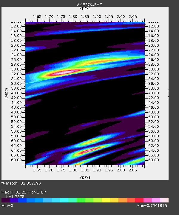
| Estimated Moho Depth: |
31.25 km |
| Estimated Crust Vp/Vs: |
1.76 |
| Assumed Crust Vp: |
6.522 km/s |
| Estimated Crust Vs: |
3.711 km/s |
| Estimated Crust Poisson's Ratio: |
0.26 |
|
| Radial Match: |
82.352196 % |
| Radial Bump: |
400 |
| Transverse Match: |
73.57567 % |
| Transverse Bump: |
400 |
| SOD ConfigId: |
25131211 |
| Insert Time: |
2021-08-02 15:23:44.363 +0000 |
| GWidth: |
2.5 |
| Max Bumps: |
400 |
| Tol: |
0.001 |
|

Signal To Noise
| Channel | StoN | STA | LTA |
| AK:E27K: :BHZ:20210719T15:34:42.300004Z | 1.9236917 | 1.2132436E-7 | 6.3068505E-8 |
| AK:E27K: :BHN:20210719T15:34:42.300004Z | 1.0270315 | 2.7472012E-8 | 2.6748948E-8 |
| AK:E27K: :BHE:20210719T15:34:42.300004Z | 1.9224442 | 5.1229616E-8 | 2.664817E-8 |
| Arrivals |
| Ps | 3.7 SECOND |
| PpPs | 13 SECOND |
| PsPs/PpSs | 17 SECOND |


