You are here: Home > Network List > AV - Alaska Volcano Observatory Stations List
> Station KAHG Katmai Hook Glacier, Alaska > Earthquake Result Viewer
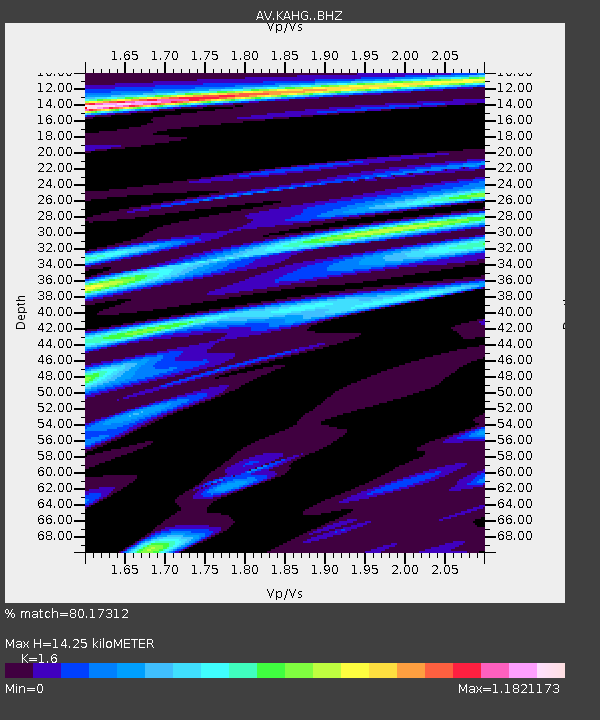
KAHG Katmai Hook Glacier, Alaska - Earthquake Result Viewer
| Earthquake location: |
Bismarck Sea |
| Earthquake latitude/longitude: |
-3.3/147.0 |
| Earthquake time(UTC): |
2021/07/19 (200) 15:22:32 GMT |
| Earthquake Depth: |
10 km |
| Earthquake Magnitude: |
5.8 Mww |
| Earthquake Catalog/Contributor: |
NEIC PDE/us |
|
| Network: |
AV Alaska Volcano Observatory |
| Station: |
KAHG Katmai Hook Glacier, Alaska |
| Lat/Lon: |
58.49 N/154.55 W |
| Elevation: |
923 m |
|
| Distance: |
76.9 deg |
| Az: |
27.354 deg |
| Baz: |
240.875 deg |
| Ray Param: |
0.0506677 |
| Estimated Moho Depth: |
14.25 km |
| Estimated Crust Vp/Vs: |
1.60 |
| Assumed Crust Vp: |
6.438 km/s |
| Estimated Crust Vs: |
4.024 km/s |
| Estimated Crust Poisson's Ratio: |
0.18 |
|
| Radial Match: |
80.17312 % |
| Radial Bump: |
400 |
| Transverse Match: |
85.30422 % |
| Transverse Bump: |
400 |
| SOD ConfigId: |
25131211 |
| Insert Time: |
2021-08-02 15:27:46.558 +0000 |
| GWidth: |
2.5 |
| Max Bumps: |
400 |
| Tol: |
0.001 |
|

Signal To Noise
| Channel | StoN | STA | LTA |
| AV:KAHG: :BHZ:20210719T15:33:53.539995Z | 3.7629437 | 2.1847431E-7 | 5.8059417E-8 |
| AV:KAHG: :BHN:20210719T15:33:53.539995Z | 0.8315099 | 3.0357437E-8 | 3.6508812E-8 |
| AV:KAHG: :BHE:20210719T15:33:53.539995Z | 2.6004736 | 8.948797E-8 | 3.441218E-8 |
| Arrivals |
| Ps | 1.4 SECOND |
| PpPs | 5.6 SECOND |
| PsPs/PpSs | 6.9 SECOND |


