You are here: Home > Network List > AV - Alaska Volcano Observatory Stations List
> Station KARR Katmai Rainbow River, Alaska > Earthquake Result Viewer
KARR Katmai Rainbow River, Alaska - Earthquake Result Viewer
| Earthquake location: |
Bismarck Sea |
| Earthquake latitude/longitude: |
-3.3/147.0 |
| Earthquake time(UTC): |
2021/07/19 (200) 15:22:32 GMT |
| Earthquake Depth: |
10 km |
| Earthquake Magnitude: |
5.8 Mww |
| Earthquake Catalog/Contributor: |
NEIC PDE/us |
|
| Network: |
AV Alaska Volcano Observatory |
| Station: |
KARR Katmai Rainbow River, Alaska |
| Lat/Lon: |
58.50 N/154.71 W |
| Elevation: |
610 m |
|
| Distance: |
76.9 deg |
| Az: |
27.309 deg |
| Baz: |
240.731 deg |
| Ray Param: |
0.050716408 |
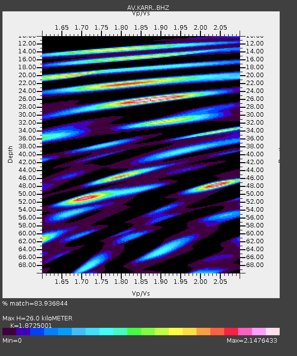
| Estimated Moho Depth: |
26.0 km |
| Estimated Crust Vp/Vs: |
1.87 |
| Assumed Crust Vp: |
6.438 km/s |
| Estimated Crust Vs: |
3.438 km/s |
| Estimated Crust Poisson's Ratio: |
0.30 |
|
| Radial Match: |
83.936844 % |
| Radial Bump: |
400 |
| Transverse Match: |
69.81747 % |
| Transverse Bump: |
400 |
| SOD ConfigId: |
25131211 |
| Insert Time: |
2021-08-02 15:27:49.558 +0000 |
| GWidth: |
2.5 |
| Max Bumps: |
400 |
| Tol: |
0.001 |
|
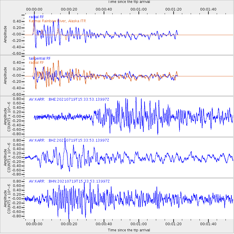
Signal To Noise
| Channel | StoN | STA | LTA |
| AV:KARR: :BHZ:20210719T15:33:53.13997Z | 3.6904855 | 1.5541879E-7 | 4.2113374E-8 |
| AV:KARR: :BHN:20210719T15:33:53.13997Z | 1.3095574 | 1.0655299E-7 | 8.136565E-8 |
| AV:KARR: :BHE:20210719T15:33:53.13997Z | 1.9055244 | 1.2728688E-7 | 6.6798876E-8 |
| Arrivals |
| Ps | 3.6 SECOND |
| PpPs | 11 SECOND |
| PsPs/PpSs | 15 SECOND |


