You are here: Home > Network List > AV - Alaska Volcano Observatory Stations List
> Station SPCR Ckakachatna River, Mount Spurr, Alaska > Earthquake Result Viewer
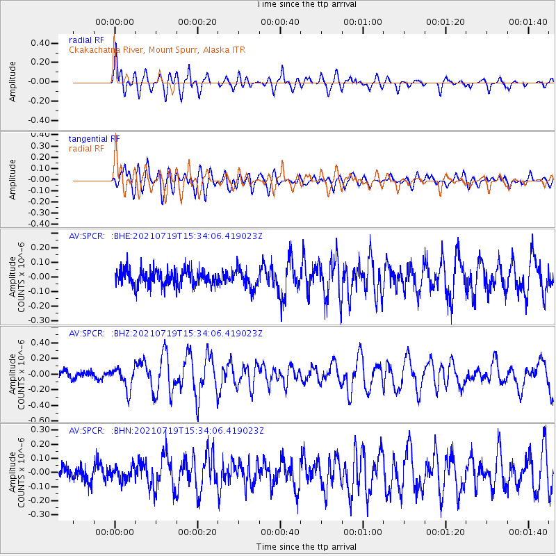
SPCR Ckakachatna River, Mount Spurr, Alaska - Earthquake Result Viewer
*The percent match for this event was below the threshold and hence no stack was calculated.
| Earthquake location: |
Bismarck Sea |
| Earthquake latitude/longitude: |
-3.3/147.0 |
| Earthquake time(UTC): |
2021/07/19 (200) 15:22:32 GMT |
| Earthquake Depth: |
10 km |
| Earthquake Magnitude: |
5.8 Mww |
| Earthquake Catalog/Contributor: |
NEIC PDE/us |
|
| Network: |
AV Alaska Volcano Observatory |
| Station: |
SPCR Ckakachatna River, Mount Spurr, Alaska |
| Lat/Lon: |
61.20 N/152.21 W |
| Elevation: |
984 m |
|
| Distance: |
79.3 deg |
| Az: |
25.483 deg |
| Baz: |
242.509 deg |
| Ray Param: |
$rayparam |
*The percent match for this event was below the threshold and hence was not used in the summary stack. |
|
| Radial Match: |
78.7975 % |
| Radial Bump: |
400 |
| Transverse Match: |
76.21694 % |
| Transverse Bump: |
400 |
| SOD ConfigId: |
25131211 |
| Insert Time: |
2021-08-02 15:28:27.963 +0000 |
| GWidth: |
2.5 |
| Max Bumps: |
400 |
| Tol: |
0.001 |
|
Signal To Noise
| Channel | StoN | STA | LTA |
| AV:SPCR: :BHZ:20210719T15:34:06.419023Z | 2.8638353 | 1.4896062E-7 | 5.2014382E-8 |
| AV:SPCR: :BHN:20210719T15:34:06.419023Z | 0.9737819 | 5.0487078E-8 | 5.1846392E-8 |
| AV:SPCR: :BHE:20210719T15:34:06.419023Z | 1.2123574 | 6.6834396E-8 | 5.5127636E-8 |
| Arrivals |
| Ps | |
| PpPs | |
| PsPs/PpSs | |


