You are here: Home > Network List > AV - Alaska Volcano Observatory Stations List
> Station WAZA Wrangell Zanetti, Alaska > Earthquake Result Viewer
WAZA Wrangell Zanetti, Alaska - Earthquake Result Viewer
| Earthquake location: |
Bismarck Sea |
| Earthquake latitude/longitude: |
-3.3/147.0 |
| Earthquake time(UTC): |
2021/07/19 (200) 15:22:32 GMT |
| Earthquake Depth: |
10 km |
| Earthquake Magnitude: |
5.8 Mww |
| Earthquake Catalog/Contributor: |
NEIC PDE/us |
|
| Network: |
AV Alaska Volcano Observatory |
| Station: |
WAZA Wrangell Zanetti, Alaska |
| Lat/Lon: |
62.07 N/144.15 W |
| Elevation: |
2531 m |
|
| Distance: |
83.1 deg |
| Az: |
26.248 deg |
| Baz: |
249.706 deg |
| Ray Param: |
0.046413153 |
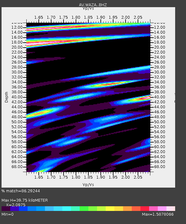
| Estimated Moho Depth: |
39.75 km |
| Estimated Crust Vp/Vs: |
2.10 |
| Assumed Crust Vp: |
6.566 km/s |
| Estimated Crust Vs: |
3.13 km/s |
| Estimated Crust Poisson's Ratio: |
0.35 |
|
| Radial Match: |
86.29244 % |
| Radial Bump: |
400 |
| Transverse Match: |
81.41044 % |
| Transverse Bump: |
400 |
| SOD ConfigId: |
25131211 |
| Insert Time: |
2021-08-02 15:28:35.870 +0000 |
| GWidth: |
2.5 |
| Max Bumps: |
400 |
| Tol: |
0.001 |
|

Signal To Noise
| Channel | StoN | STA | LTA |
| AV:WAZA: :BHZ:20210719T15:34:26.89998Z | 2.8663664 | 1.7380303E-7 | 6.0635315E-8 |
| AV:WAZA: :BHN:20210719T15:34:26.89998Z | 1.2082253 | 6.264841E-8 | 5.1851593E-8 |
| AV:WAZA: :BHE:20210719T15:34:26.89998Z | 0.85006094 | 5.794426E-8 | 6.816483E-8 |
| Arrivals |
| Ps | 6.8 SECOND |
| PpPs | 18 SECOND |
| PsPs/PpSs | 25 SECOND |


