You are here: Home > Network List > C8 - Canadian Seismic Research Network () Stations List
> Station GRIB Gribbell Island, BC, CA > Earthquake Result Viewer
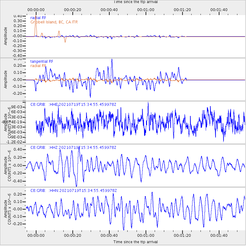
GRIB Gribbell Island, BC, CA - Earthquake Result Viewer
*The percent match for this event was below the threshold and hence no stack was calculated.
| Earthquake location: |
Bismarck Sea |
| Earthquake latitude/longitude: |
-3.3/147.0 |
| Earthquake time(UTC): |
2021/07/19 (200) 15:22:32 GMT |
| Earthquake Depth: |
10 km |
| Earthquake Magnitude: |
5.8 Mww |
| Earthquake Catalog/Contributor: |
NEIC PDE/us |
|
| Network: |
C8 Canadian Seismic Research Network () |
| Station: |
GRIB Gribbell Island, BC, CA |
| Lat/Lon: |
53.34 N/129.14 W |
| Elevation: |
418 m |
|
| Distance: |
88.9 deg |
| Az: |
36.608 deg |
| Baz: |
263.154 deg |
| Ray Param: |
$rayparam |
*The percent match for this event was below the threshold and hence was not used in the summary stack. |
|
| Radial Match: |
63.93731 % |
| Radial Bump: |
400 |
| Transverse Match: |
67.44638 % |
| Transverse Bump: |
400 |
| SOD ConfigId: |
25131211 |
| Insert Time: |
2021-08-02 15:29:17.107 +0000 |
| GWidth: |
2.5 |
| Max Bumps: |
400 |
| Tol: |
0.001 |
|
Signal To Noise
| Channel | StoN | STA | LTA |
| C8:GRIB: :HHZ:20210719T15:34:55.459978Z | 1.3648465 | 1.0248875E-7 | 7.5091776E-8 |
| C8:GRIB: :HHN:20210719T15:34:55.459978Z | 0.90124357 | 5.5050695E-8 | 6.1083036E-8 |
| C8:GRIB: :HHE:20210719T15:34:55.459978Z | 1.0353096 | 3.453779E-9 | 3.3359868E-9 |
| Arrivals |
| Ps | |
| PpPs | |
| PsPs/PpSs | |


