You are here: Home > Network List > CI - Caltech Regional Seismic Network Stations List
> Station SMM Simmler, CA, USA > Earthquake Result Viewer
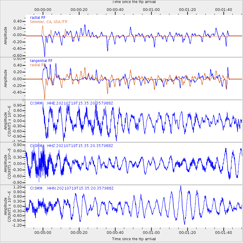
SMM Simmler, CA, USA - Earthquake Result Viewer
*The percent match for this event was below the threshold and hence no stack was calculated.
| Earthquake location: |
Bismarck Sea |
| Earthquake latitude/longitude: |
-3.3/147.0 |
| Earthquake time(UTC): |
2021/07/19 (200) 15:22:32 GMT |
| Earthquake Depth: |
10 km |
| Earthquake Magnitude: |
5.8 Mww |
| Earthquake Catalog/Contributor: |
NEIC PDE/us |
|
| Network: |
CI Caltech Regional Seismic Network |
| Station: |
SMM Simmler, CA, USA |
| Lat/Lon: |
35.31 N/120.00 W |
| Elevation: |
599 m |
|
| Distance: |
94.3 deg |
| Az: |
54.987 deg |
| Baz: |
269.081 deg |
| Ray Param: |
$rayparam |
*The percent match for this event was below the threshold and hence was not used in the summary stack. |
|
| Radial Match: |
54.716618 % |
| Radial Bump: |
400 |
| Transverse Match: |
45.013157 % |
| Transverse Bump: |
400 |
| SOD ConfigId: |
25131211 |
| Insert Time: |
2021-08-02 15:30:43.777 +0000 |
| GWidth: |
2.5 |
| Max Bumps: |
400 |
| Tol: |
0.001 |
|
Signal To Noise
| Channel | StoN | STA | LTA |
| CI:SMM: :HHZ:20210719T15:35:20.357988Z | 0.87070596 | 3.5483248E-7 | 4.0752275E-7 |
| CI:SMM: :HHN:20210719T15:35:20.357988Z | 0.7547682 | 2.2687021E-7 | 3.0058263E-7 |
| CI:SMM: :HHE:20210719T15:35:20.357988Z | 0.965983 | 4.8410504E-7 | 5.011528E-7 |
| Arrivals |
| Ps | |
| PpPs | |
| PsPs/PpSs | |


